


Calder Bridge
![]()
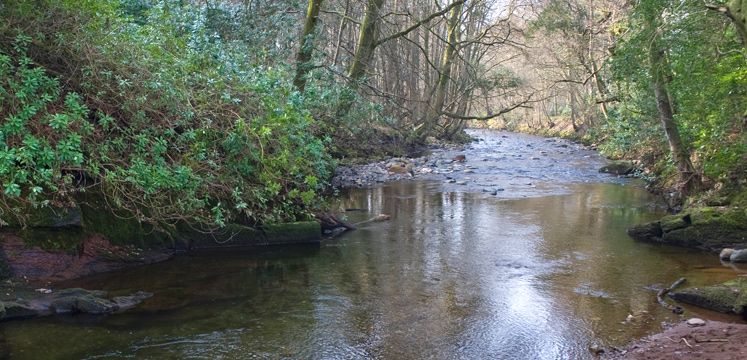
A tranquil, riverside walk next to the stunning ruins of Calder Abbey, described as one of Britain’s most enchanting ecclesiastic relics.
OS Explorer Map OL6
Route for many. 2km distance.
Difficulty
Easy
Duration
0.5 hours
Distance
0.99km / 0.62miles
Route
From the car park, head towards St. Bridget’s Church and go through a metal gate on the left. There is a zig-zag path to bypass the steps but be aware that this is steep (1:8) and has a cross slope. The path then winds gently downhill, crossing a small stream and raised causeway to the wooded banks of the River Calder.
This is a particularly beautiful stretch of the river. The sandstone cliffs on the far banks are dramatic and the river alternates between deep pools and fast stretches. It is a popular spot for trout and salmon fishermen. Look out for dippers and wagtails, as well as herons and kingfishers.
After 1 km, you arrive at the boundary of Calder Abbey. There is no access to the ruins (which are to the left of and behind the more modern but also very impressive manor house), as they are in private grounds, but you can get a sense of the grandeur and importance of the Abbey in medieval times. You should then turn around and return to Calder Bridge the same way.
Please note that this route has been re-graded to ‘for many’ due to a steep slope at the very start. The map below will be updated shortly.
Please note that mobility scooters must be class 2 or 3 on the route.
Download the route map for Miles Without Stiles 22: Calder Bridge
Details
Start point:
Small informal car park near the church at Calder Bridge
Postcode: CA20 1DH
Grid reference: NY 042061
W3W: ///again.dweller.blacken
Turning point:
Grid reference: NY 051063
W3W: ///solution.reworked.tables
Facilities:
None on route, but there is a pub in Calder Bridge and (with Changing Places facilities, radar key required) at Ravenglass Station a few miles away..
Getting there:
No public transport to route start point. Car: A5086 and A595 from Cockermouth, or A5092 and A595 beyond Broughton in Furness.

