Skip to content
aerial landscape view of ullswater green fields and fells with a low cloud inversion in the valley bottoms

WHS marketing toolkits

Home Protect World Heritage Site WHS marketing toolkits

To promote wider awareness of the Lake District’s World Heritage status, we’ve produced an extensive Brand Toolkit which is available to businesses and other organisations operating within the World Heritage Site.

There’s also a business toolkit provided by Cumbria Tourism which is closely linked to the World Heritage toolkit, details of which can be found below.

The packs include logos in a jpeg format suitable for digital and print use. Some logos are included in 2 colour ways (black text on white and a reversal), with a selection also available in 2 or 3 line formats.

Please review the included ‘read me’ file and the brand guidelines linked below prior to using any of the World Heritage brand assets.

For more information, or if you require any of the brand assets in a different format, please contact lakeswh@lakedistrict.gov.uk.

Please note, the list of available assets has recently been updated with files split into groups, rather than individual downloads. You may need to download more than one of the brand packs to find the asset you’re looking for.

World Heritage Site brand guidelines

Please read the guidelines before using any of the assets linked from this page.

Concise guidelines (PDF)
Full guidelines (PDF)

Logos

Included with the toolkit are brand guidelines showing how the brand assets can be used, and a wide selection of logos to encourage visitor growth and recognition of the World Heritage inscription.

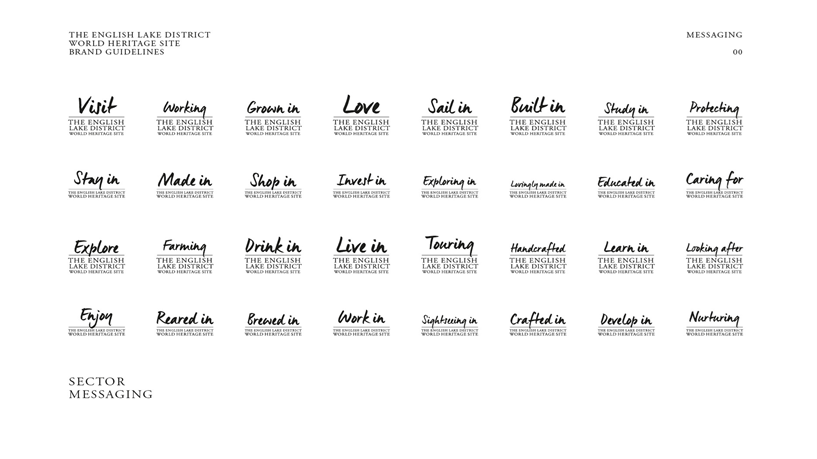
A number of the below – Welcome to, Enjoy, Explore, Love, Made in, Sail in, Stay in and Visit are available in Chinese, Japanese, French, Spanish and German, both as 2 line and 3 line versions and in all three formats. If you would like a translated version, please get in touch (opens email).

Examples of how the World Heritage branding can be used include:

  • Displaying a logo on your product or packaging for items made in the Lake District
  • Including a logo on your website and email communications
  • Adding a logo to printed materials such as leaflets, guides and menus
  • Use on signage and promotional campaigns

Logo pack downloads

Each of the activities logos includes a 2 or 3 line variant of [activity] in the English Lake District World Heritage Site.

Activities A-D, e.g. Brewed, Crafted, Develop, Dine, Drink (zip)
Activities E-G, e.g. Enjoy, Explore, Farming, Grown (zip)
Activities H-L, e.g. Handcrafted, Invest, Learn, Live, Look After, Love (zip)
Activities M-R, e.g. Made, Nurture, Protect, Reared, Ride (zip)
Activities S-T, e.g. Sail, Shop, Sightseeing, Stay, Study, Touring (zip)
Activities U-W, e.g. Understanding, Visit, Work, Working (zip)
Welcome badges, e.g. Welcome to the English Lake District World Heritage Site (zip)
Seasons Logos, e.g. Christmas, Easter, Summer, etc. (zip)

Other brand asset downloads

Please find below social media banners, suitable for X and Facebook.

Email signatures, to show your email was sent from the English Lake District World Heritage Site.

A separate series of logos for the WHS Working Groups.


Social media banners (zip)
Email signatures (zip)
WHS working groups logos (zip)

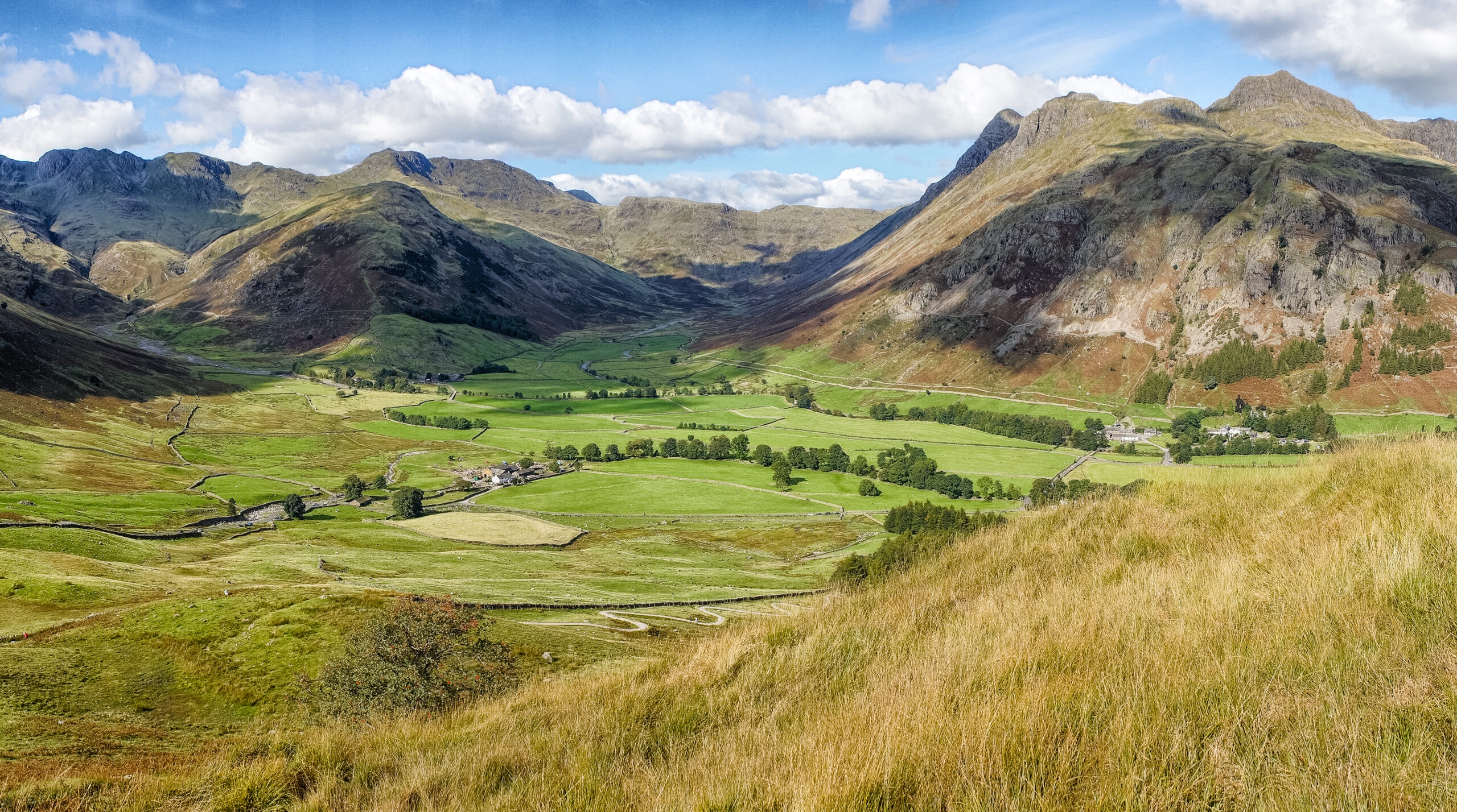
The English Lake District's 13 valleys

Nestling serenely in the north-west corner of the Lake District, Buttermere’s classic U-shaped glacial valley contains not one but three lakes – Buttermere, Crummock Water and Loweswater. Buttermere runs out from the central fells, through the meandering Derwent Valley on towards the mouth of the lovely Solway Firth, creating a scene that Alfred Wainwright described in his ‘Pictorial Guides to the Lakeland Fells’  as a place where “loneliness, solitude and silence prevail that make the  scene unforgettable”.

Neolithic or Bronze Age settlement in the valley can be traced through the rock art at Mill Beck, Buttermere and Crummock Water. There are also a number of prehistoric summit cairns, including those at Carling Knott and Grasmoor, and it is thought that an Iron Age hillfort stood at Loweswater. Early medieval and Norse settlement is reflected in words such as ‘thwaite’ (clearing), ‘scale’ (summer farm) and ‘kirk’ (church) in local place names.

Sheep farming, as it has been for centuries, is the principal occupation in Buttermere and it is an important grazing place for the hardy Herdwick breed. Other industries here included some limited mining, thanks to the discovery of haematite in the west side of the valley and some iron production in medieval times. The remains of 14 iron smelting furnace sites, or bloomeries, can be found around Crummock Water, Loweswater and east of Buttermere. But it is the results of the mining of Lakeland slate that dominate the landscape at the head of the valley at Honister Hause.

In their 1799 walking tour, both Wordsworth and Coleridge visited Buttermere. In his ‘Notebook’, Coleridge wrote lyrically of a striking yew tree. This was the same tree later celebrated by Wordsworth in his poem ‘Yew Trees’. Although damaged and reduced by a storm, the yew tree still stands today on the bank of the Whit Beck, behind the village hall. JMW Turner’s visit to the valley was transformative for him as an artist and his spectacular ‘Buttermere Lake, with Part of Cromackwater, Cumberland, a Shower’ was shown in an exhibition at the Royal Academy. Broadcaster Melvyn Bragg wrote an account of the true story of Mary Robinson in his popular novel ‘The Maid of Buttermere’. Mary was the daughter of the landlord of the Fish Inn, a hostelry that still welcomes visitors in the valley today.

The story of conservation around Buttermere is a fascinating one. In 1814, with the encouragement and involvement of Wordsworth, John Marshall, the Leeds industrialist, bought extensive landholdings around the lakes of Buttermere, Crummock Water and Loweswater, with the aim of maintaining the beauty of the area. Large parts of the valley have subsequently been purchased by the National Trust and the whole of the valley head of Buttermere is covered by a restrictive covenant agreed with G. M. Trevelyan in 1937. Canon Rawnsley also managed to lead a successful protest to prevent the building of a railway from Keswick to Buttermere to serve the Honister slate quarry. Together, these conservation activities have led to the preservation of a strikingly beautiful and pastoral valley.

The largest of the 13 Lakeland valleys, the Borrowdale and Bassenthwaite valley extends from the high fells of Rossett Pike and Esk Hause in the south to the northern edge of the Caldbeck Fells and the wide, coastal plain of the Solway Firth. It includes the major glacial lakes of Derwent Water and Bassenthwaite as well as the busy tourist centre of Keswick.

The valley is also home to rare upland hay meadows and its steep fellsides carry one of the largest oak woodlands in England, containing many rare native species.

Borrowdale and Bassenthwaite have been settled from at least the Neolithic period and there is evidence there was a stone axe production site on Carrock Fell. Other early monuments from this period include the large stone circle at Elva Plain, east of Bassenthwaite Lake. The small hillforts at Castle Crag in Borrowdale and Castle How by Bassenthwaite Lake may date to either the later prehistoric or early medieval periods. There is a Roman fort at Caermote, north of Bassenthwaite Lake, and a wellpreserved group of Roman period native settlements survive at Aughertree Fell.

Borrowdale was a key area for the Company of Mines Royal, set up by the English Crown in 1568. The remains of Mines Royal copper and lead mines can be seen at Goldscope in the Newlands valley, along with the copper mines of Long Work, St Thomas’ Work and Dalehead. What’s left of a unique mining operation can be found on the slopes above Seathwaite in Borrowdale where ‘wad,’ or pure graphite, was mined from the 16th century. In the 1800s, Keswick became the world centre of pencil manufacturing and the Keswick Pencil Museum, on the site of a 1920s factory, tells the story. Slate and wool are also vital industries to the region.

In 1778, Thomas West’s guidebook identified a series of key viewing stations around Derwent Water and Bassenthwaite and by the late 18th century, Keswick began to develop as a tourist centre for the wealthier visitors. The Bowder Stone became, and still is, one of the quirkiest tourist attractions. Located in the ‘Jaws of Borrowdale’, the enormous stone balances improbably on one edge and is today owned by the National Trust. Also under the National Trust’s protection is the photogenic Ashness Bridge, offering spectacular views over Bassenthwaite Lake and the River Derwent.

Poets Southey and Coleridge both took up residence at various times at Greta Hall in Keswick, while the poet Shelley also lived briefly in Keswick. The Wordsworths were frequent visitors to the region and Borrowdale features in many of William Wordsworth’s poems.

The Borrowdale and Bassenthwaite Valley is also highly important for the early conservation movement. John Marshall, and others keen to preserve the beauty of the area, bought key parts of Borrowdale in order to prevent damaging development. Canon Rawnsley, vicar for many years of the Parish of Crosthwaite, led the battle against a proposed railway on the west side of Derwent Water to the Honister slate quarries, and the National Trust, of which Rawnsley was a founder, made its first purchases of land in the English Lake District here at Brandlehow.

Lying in the central southern part of the Lake District, the valley of Coniston and its linear, glacial lake, Coniston Water, is guarded by the high, rugged fells of Coniston Old Man and Wetherlam and overlooked by extensive woodlands and forest plantations.

The legacy of mining and quarrying on the fellsides, pastoral farming on lower ground, woodland industries, and the busy village of Coniston, all come together in this striking and characterful working landscape.

There’s evidence of prehistoric activity on the low fells in the form of burial cairns and small stone circles. Early medieval settlements give themselves away through the survival of Old Norse place names. Much of the valley’s agricultural landscape also owes its appearance to this period. Medieval monasteries owned a lot of the land in the area between Coniston and Windermere, with the abbots at Furness Abbey granted almost all of the land in High and Low Furness in 1127.

Large areas of the valley were used for deer parks by both Furness Abbey and private landlords up until the 17th century and this was also a period of much change to agricultural practices.

Industry has played an important role on the character of Coniston. Iron was smelted from the medieval period until the 20th century using local charcoal and copper mining also continued into the early 20th century. Slate was also a vital resource, with quarrying providing employment for more than 100 men in the Coniston area in the 1830s. There is still some slate quarrying going on today.

The quarries and mines led, in turn, to a demand for gunpowder. The gunpowder works of the Coniston valley helped to contribute a large amount of the United Kingdom’s needs for gunpowder from the late 18th to the early 20th century.

In 1859, the Coniston railway opened and there was an immediate influx of tourists, with the Steam Yacht Gondola built to provide leisure trips on Coniston Water to entertain the increasing number of visitors.

The pursuit of beauty extended to landscape design, an example of this being Monk Coniston, bought by Beatrix Potter from the Marshall family, and then later acquired by the National Trust.

William Wordsworth was a pupil at the grammar school in Hawkshead and wrote of Coniston and its people in his poems, most notably in ‘The Prelude’. JMW Turner created ‘Morning among the Coniston Fells’ one of his key oil paintings here, and in the later 19th century leading art critic John Ruskin took up residence at Brantwood, directly looking over the lake.

Coniston has inspired everything from heavy industry to great art over the centuries and still remains as a valley of extraordinary contrasts, textures and beauty.

Also known as Dunnerdale, the more intimate and narrow valley of the River Duddon has no lake of its own and is enclosed at its head by the rugged high fells of Harter Fell, Ulpha Fell and Grey Friar, with two of England’s highest mountain passes meeting here at Cockley Beck. The valley then runs south-west to meet the wide estuary and the Irish Sea.

The Duddon landscape has changed little since the 18th century, when William Wordsworth wrote “Time, in most cases, and nature everywhere, have given a sanctity to the humble works of man, that are scattered over this peaceful retirement” (‘Notes to The River Duddon’, A Series of Sonnets’ 1820).

Settlement here dates to at least the Neolithic period, with the remains of one of the most impressive of the Lake District’s many stone circles to be found at Swinside Farm. Traces of Bronze Age settlers are also visible on the fells above the valley. Hardknott Roman fort sits high on the pass of the same name that winds its way westwards up from the head of the valley. There’s no obvious medieval settlement centre in the Duddon Valley, although nearby Furness Abbey was influential here, with Monk Foss Farm taking its name from the connection. The abbeys would also have helped develop and control the medieval iron industry. Today, the valley is still thinly populated with two small hamlets at Seathwaite and Ulpha and the nearest larger village at Broughton-in-Furness, just to the east of the estuary.

Its combination of geology, woodland and water resources made the Duddon Valley an important location for industry over several centuries. This included slate quarrying, copper mining, iron smelting, peat extraction and cloth manufacturing. Although now there is little in the way of industry here, there are still the remains of many charcoal burning ‘pitsteads’ on the western side of the valley. There are also the traces of carding mills where wool would have been prepared for spinning, and ‘retting’ ponds where hemp grown for rope would be soaked.

The valley was the subject of a series of sonnets published by Wordsworth in 1820. The Duddon Sonnets received more praise in his lifetime than any other of his works. When JMW Turner read these, it inspired him to visit and paint Duddon Sands. Coleridge also wrote of the valley in his 1802 ‘Notebook’, calling it “O lovely, lovely Vale!”.

Unlike other areas of the Lake District, there has been little to trouble conservationists in the Duddon Valley over the centuries. There were protests over the development of Seathwaite Tarn as a drinking water reservoir in the early 20th century and in recent years some steps have been taken to remove inappropriate infrastructure from the landscape. Friends of the Lake District helped reduce the impact of commercial forestry in the upper valley, making Black Hall Farm exempt from planting. The National Trust subsequently took possession of the farm.

The Duddon Valley may be a modest, lessfrequented place but it is a rich, beautiful and inspiring landscape with a significant identity and history

Tucked into the central far west of the Lake District, Ennerdale runs from east to west from the high central fells to the rolling hills and moorland of West Cumbria and the Irish Sea coastal plain. It is the only major Lake District valley to have no public road along it.

Although sparsely populated even today, there have been settlers in Ennerdale since prehistoric times with a concentration of evidence around Stockdale Moor and Town Bank, in the form of burial sites and farming settlements. Cairns and hut circles can be found where the River Calder and Whoap Beck meet. There are also remains of Romano-British farmsteads at Low Gillerthwaite and at Tongue How. Norse immigrants would have settled here in the 12th century. During medieval times, much land would have been under monastic influence and it was at this period that the mineral potential of the valley was realised with the mining and smelting of iron ore.

In the 1920s, the Forestry Commission purchased Ennerdale and created a blanket of commercial conifer forest. This had an effect on the tradition of farming Herdwick sheep. Up until then, Ennerdale held a vital place in the Herdwick story, but 2,000 sheep had to be removed from Gillerthwaite and Ennerdale Dale when the valley was forested. However, there are still 16 farms with fell-grazing livestock in the wider Ennerdale valley.

From a literary perspective, Ennerdale inspired Wordsworth’s poem ‘The Brothers’ in 1800 after he and Coleridge visited the valley a year earlier, but perhaps the area’s largest cultural impact has been on the sport of rock climbing. It was at Pillar Rock in Ennerdale that true rock climbing began. Previously thought unclimbable, local shepherd John Atkinson scaled Pillar in 1824 and kick-started a passion for this tricky piece of rock that climbers from all over the world share to this day.

Ennerdale has been an active place for the conservation movement. The fact that the valley has no railway today is down to strong opposition by Canon Rawnsley and the Lake District Defence Society to a line for transporting iron ore from the valley head. This was an important victory and the society went on to become The Friends of the Lake District. However, some infrastructure did arrive when Ennerdale Water was developed as a water supply for West Cumbria from 1864.

Today, the Wild Ennerdale Project continues the legacy of looking after the environment with a vision to “allow the evolution of Ennerdale as a wild valley for the benefit of people, relying more on the natural processes to shape its landscape and ecology”.

Water extraction, farming and forestry have all played their part in shaping the landscape here, but it is really its striking natural features that give Ennerdale its overwhelming character of wildness and tranquillity

Eskdale begins in the wild, lofty Lake District heartland of the Scafell massif, running south-west to the coast. This is the only place in England where mountains plunge almost directly into the sea. It is a mixed and dramatic landscape, going from steep, craggy and volcanic uplands, through softer, broader land and down to its wide open, tidal estuary at Ravenglass.

Human presence in Eskdale can be traced back to around 8,000BC, when Mesolithic hunters settled by the sea. Later prehistoric sites include both Neolithic and Bronze Age stone circles and settlement remains on Boot Bank and around Devoke Water. There are also burial sites at Eskdale Moor, Bootle Fell, Stainton and Great Grassoms. In Roman times, forts were built on the coast at Ravenglass and high up on the mountain pass at Hardknott, where up to five hundred cavalry would have been garrisoned. Some of the Roman remains at Ravenglass now form part of the Frontiers of the Roman Empire (Hadrian’s Wall) World Heritage site.

Like many other places in the Lake District, Norse settlers and farmers left their mark through numerous place names, including Brotherilkeld meaning ‘the booth of Ulfkell’ and with the use of the word ‘thwaite’ meaning ‘a clearing’. By the 12th century, much of Eskdale was part of the Copeland Forest and used as hunting land, with manors owned by feudal barons. On the coast, Ravenglass developed as a harbour and trading port and to the south, Bootle grew in size with its market and fair charter granted in 1347. It was at the close of the 16th century that the more distinctive Lake District farmsteads began to take their modern form.

In 1875, a narrow-gauge railway was built to take iron ore away to the coast at Ravenglass and then later used to transport granite from Eskdale’s quarries. Today, La’l Ratty, as it’s known locally, is a popular tourist attraction boasting the oldest working 15” gauge locomotive in the world.

Because of its more remote, westerly position, Eskdale didn’t receive the same degree of attention from 18th century visitors as did the other, more accessible valleys. JMW Turner sketched Eskdale Mill at Boot but probably never visited in person, basing his work on an earlier composition by Edward Dayes. Coleridge, however, did pay a visit and wrote passionately about the landscape in his ‘Notebook’ of 1802.

From a conservation perspective, The National Trust now owns and manages a number of farms in upper Eskdale, with a total of 4,959 hectares and the Friends of the Lake District campaigned strongly against a large hydroelectric generation plan in upper Eskdale in the 1940s.

With its high mountains at one end and lovely coastline at the other, and its strong farming and industrial heritage, Eskdale has a very special character.

Running north to south from the pass of Dunmail Raise, the classic glacial U-shaped valley containing the popular tourist spots of Grasmere and Ambleside lies at the heart of the English Lake District. It is home to the two lovely but relatively small lakes of Rydal and Grasmere, both surrounded by woodland and pasture, and overlooked by craggy high fells. More than most other valleys, Grasmere, Rydal and Grasmere show off a diversity of landscape, offering a sample of everything the Lake District has to offer.

Humanity has left its mark here over the millennia. There is some Neolithic or Bronze Age rock art at Allan Bank and the possible medieval burial site of King Dunmail at Dunmail Raise to the north. A Roman fort and civilian settlement was constructed at Waterhead, Ambleside.

Industry-wise, the valley has seen much activity. Mining and slate or stone quarrying as well as charcoal production were all carried out here. The abundant water power available from the becks was used from the medieval period until the 19th century for a number of processes, including corn grinding, wooden bobbin production, crushing bark for tanning, and manufacturing linen and woollen cloth.

Tourism has played an important part in the valley’s story. Through its mention in the early guide books as well as the influence of Wordsworth, Grasmere, Rydal and Ambleside became hugely popular destinations. This was further enhanced by the building of metalled roads after 1770 and the railway to Windermere in 1847. Of course, Grasmere and Rydal are forever linked with William Wordsworth and his family as well as other important figures of the Romantic movement. The Wordsworth homes of Dove Cottage and Rydal Mount are enjoyed by visitors from all over the world. Dora’s Field in Rydal is a delightful area of woodland that was planted with wild daffodils as a memorial to Wordsworth’s daughter Dora who died at a tragically young age.

The conservation link is strong in the valley, too. Wordsworth had protested against the extension of the railway from Windermere and this was also taken up by John Ruskin. It was here, at Allan Bank on the shores of Grasmere, that Canon Rawnsley came to retire. Rawnsley was an instrumental figure in the preservation and protection of the Lakeland landscape and was formative in the birth of the National Trust. The Trust now owns many properties in the valley, including the more recently bought traditional farmhouse of High Lickbarrow Farm, the iconic, quirky 17th century Bridge House in Ambleside and the beautiful, tranquil designed landscape of High Close Estate and Arboretum. The 16th century Rydal Hall, now owned by the Diocese of Carlisle, is another example of a designed landscape and features The Grot, a tiny summerhouse looking out to the waterfall and an example of the early Picturesque movement.

The Grasmere, Rydal and Ambleside Valley is a thriving landscape of natural beauty, community and industry, with magnificent surviving villas, designed landscapes and major artistic importance.

Like Thirlmere, Haweswater is a reservoir valley, flooded in 1935 to create a long, curving body of water running south-west to north-east. It is a tranquil, less visited corner of the Lake District, lying on the region’s north-east edge. Its lack of farms and inbye grazing along the reservoir’s entire length lends most of Haweswater a sense of wilderness.

The head of the valley is dominated by Branstree, Harter Fell, Mardale Ill Bell, High Street and Kidsty Pike, and features the tarns of Small Water and Blea Water, the deepest mountain tarn in the Lake District. At the other end, the valley opens out into the broad and gentle limestone Lowther Valley. Thomas West in his ‘Guide to the Lakes’ described Haweswater as a “sweet but unfrequented lake” and “most pleasantly elegant”.

Although the flooding of Haweswater has hidden any traces of prehistoric settlement in the valley bottom, there is evidence of Bronze Age activity on higher ground, including standing stones, burial cairns and a hillfort at Castle Crag. The highest Roman road in England, known as High Street, and linking forts at Penrith and Ambleside, runs along the high fells on the west side of the valley.

There was also some monastic influence in Haweswater because of the proximity of Shap Abbey which was founded in 1191. Nearby is Lowther Castle, historic seat of the Lowther family, the dominant family in Westmorland, and home to 600 hectares of landscaped parkland and grounds. Grade I listed Askham Hall to the east is another example of a fine designed landscape and formal gardens.

Apart from a little copper mining, slate quarrying and charcoal production, the only significant industry to impact the valley over the centuries is water extraction in the form of the reservoir.

The early farming landscape in the main valley of Haweswater was lost when the small hamlet of Mardale, with its church and Dun Bull Inn, was flooded by the Manchester Corporation. Up until that time, the inn was famous for its autumnal shepherds’ meet.

Before the flooding, the existing lake of Haweswater was the highest natural lake in the Lake District at 211 metres.

At the start of their famous walking tour in 1799, Wordsworth and Coleridge stayed at Bampton, the village at the foot of Haweswater. Both men walked along the shore of the old lake and over the passes into Longsleddale and then Kentmere. Haweswater’s Kidsty Pike subsequently features in Wordsworth’s 1800 poem ‘The Brothers’: “On that tall pike (It is the loneliest place of all these hills) There were two springs which bubbled side by side As if they had been made that they might be Companions for each other: the huge crag Was rent with lightning – one hath disappeared; The other, left behind, is owing still”.

The Haweswater Valley area is the only valley area in the Lake District with no National Trust land ownership. However, United Utilities, the private water company, which has inherited the Manchester Corporation estate, is assisted in its management of the estate by the Royal Society for the Protection of Birds.

Langdale takes its name from the Old Norse term for ‘long valley’. Located right at the heart of the Lake District, this classic, stunning example of a U-shaped glacial valley was described by John Ruskin as “…the loveliest rock scenery, chased with silver waterfalls, that I ever set foot or heart upon”.

Running east to west from the high central Lake District fells, Langdale boasts Bowfell and Crinkle Crags at its head before meeting with the adjoining Grasmere, Rydal and Ambleside valley to the north of Windermere. One thing it doesn’t have, though, is a lake, which is unusual for a Lakeland valley of this size.

Human activity in Langdale can be traced to Neolithic times and the production of stone axes along with panels of rock art visible on a pair of boulders at Copt Howe, near Chapel Stile. The earliest permanent human settlement was probably in the Bronze Age and when the Romans arrived in the region, they built a road through Little Langdale from their fort in

Ambleside to the one on Hardknott Pass. Norse settlers of the 10th century still have their influence in many local place names, some of which mingled with Old English. Documented land use in Langdale began in the 11th century and by the 16th century there were ten farms recorded here. Langdale today is an important valley for the local Herdwick sheep, with around half of it used specifically as high grazing land for this hardy local breed.

When visitors started to come to the Lake District in significant numbers, Langdale was slow to become a tourist attraction. It didn’t feature in Thomas West’s famous ‘Guide to the Lakes’ and relied on rock climbing as its main draw with many locals acting as guides to those who wanted to climb the crags. Wordsworth did much to increase the appreciation of this lovely valley, writing about Blea Tarn in his poem ‘The Excursion’ and Dungeon Ghyll Force in ‘The Idle-Shepherd Boys’. He also referred to it in one text as a “must visit” valley.

From a conservation point of view, Langdale has never really been troubled by any major commercial projects or controversial infrastructure, yet it has played a key part in the development of the conservation movement in the Lake District in the 20th century.

Educational pioneer, George Trevelyan, who once had a family holiday home in the valley, is known for his donations of Langdale farms to the National Trust. Beatrix Potter also donated areas of Langdale, and today the National Trust owns and cares for the majority of the valley. There is also the National Trust’s High Close Estate and Arboretum, a beautiful 11 acre garden between Elterwater and Grasmere.

In short, Langdale’s narrow valley enjoys a broad history and a wealth of attractions to all who visit it.

Although relatively small in size, the valley of Thirlmere, formerly known as Wythburn, is dominated by its large reservoir and its looming, steep-sided fells. The bulk of Hellvellyn hangs impressively over its eastern edge with the mighty Skiddaw and Blencathra to the north. Dunmail Raise to the south of Thirlmere is considered to be the boundary between the north and south Lake District. The famous cairn at the summit of Dunmail Raise is said to be the burial place of King Dunmail, the last monarch of the medieval kingdom of Cumbria, dating to around 945AD.

One of the best-known Lakeland archaeological sites is the stone circle at Castlerigg, just to the east of Keswick, which probably dates to Neolithic times and sits in the dramatic natural amphitheatre formed by the surrounding fells. There are also good examples of Neolithic rock art at Steel End and a Bronze Age ring cairn on Armboth Fell.

Today, it is the physical aspects of the water industry that stand out in the main valley. The Thirlmere reservoir is the most obvious of these but the dam infrastructure itself is considered to be of historic value. It was the first ever masonry gravity dam and one of only two arch dams in England and it supplies Manchester with water via a 96-mile long underground aqueduct. Other industries to impact Thirlmere were copper and lead mining as well as slate quarrying.

Thirlmere’s history tells the story of a politicised landscape preservation movement, where the struggle between natural beauty and industry was tested on a national scale for the very first time. The Thirlmere Defence Association formed in 1877 to oppose the flooding of the valley and the creation of the reservoir. Visionaries such as Canon Rawnsley and the social reformer Octavia Hill, influenced by the philosophy of John Ruskin, joined the fight. But Parliament voted in favour of the Manchester Corporation Water Works and the thirsty, fast-growing urban population in Manchester, and the dam was built. Today, United Utilities owns 4,700 hectares of land in the Thirlmere Valley and the reservoir continues to supply around 11% of the water demand of the North West of England.

But despite the defeat, the battle was a significant moment in the history of the conservation movement, both in the UK and globally. It inspired the formation of the National Trust and it brought to a head the appreciation of the vulnerability of the Lake District landscape, and public access to it.

Thirlmere is also greatly important to the Romantic writers’ and artists’ movement and was the location for the ‘Rock of Names’ – the customary meeting point for the Wordsworths and Samuel Taylor Coleridge, and now reconstructed and relocated to Dove Cottage in Grasmere. Thirlmere was also the inspiration for William Wordsworth’s poem ‘The Waggoner’ and Walter Scott’s poem ‘The Bridal of Triermain’ and a place that continues to inspire visitors to this day.

Ullswater carves a roughly northeastward path from the high central fells of the Helvellyn and High Street massif to meet the gentle Eden Valley. The 14.5 kilometre-long, dog-legged lake that shares the valley name is the second largest in the Lake District, after Windermere.

It was here on Ullswater’s shores at Glencoyne Wood that Wordsworth was inspired to write possibly the most famous lines of poetry in the English language: “I wandered lonely as a cloud, That floats on high o’er vales and hill, When all at once I saw a crowd, A host of golden daffodils, Beside the lake, beneath the trees, Fluttering and dancing in the breeze”. Wordsworth further acclaimed Ullswater in one of the most celebrated passages from his great autobiographical poem ‘The Prelude’.

From an early settlement point of view, the remains of prehistoric activity in Ullswater are extensive, spanning the period from Neolithic to the Iron Age. There are examples of rock art near the village of Patterdale in the south as well as stone circles and burial cairns on Askham Fell to the north. The Roman road connecting forts in Ambleside and Penrith, known as High Street, runs along the eastern fells above the valley.

The main industries in the Ullswater Valley were lead mining and slate quarrying, and some of the archaeological remains of these are of national significance. Important sites include Hartsop Hall mine and Myers Head, the latter being a well-preserved example of a late 19th century mine. But the largest mine was at Greenside, west of Glenridding, which operated from the 1820s until 1961.

The farming of Herdwick sheep features strongly in Ullswater today and the valley contains a number of important Herdwick farms, including Hartsop Hall with its Grade II listed 16th century farm buildings at the southern end of the lake. Some of the Ullswater farms had the largest flocks in the Lake District.

Ullswater became a popular tourist location for lovers of the Picturesque from the late 1700s onwards, thanks to both its dramatic scenery and ease of access from Penrith. It also featured in early guidebooks including one by Thomas West, who identified a number of viewing stations around the lake.

The beauty of the lake and its mountain backdrop inspired the building of a number of villas and creation of designed landscapes, including grounds around the stunning Aira Force waterfall, now owned by the National Trust.

The National Trust also owns and cares for the adjacent Gowbarrow Park and, over the 20th century, it gradually acquired further key properties, including iconic farms such as Glencoyne. It now owns and manages a large portion of the valley.

Ullswater has also been the scene of hardfought conservation battles. The Friends of the Lake District managed to force electricity cables to be laid underground along the southern and eastern shores of Ullswater, helping to protect a view once appreciated by Wordsworth and JMW Turner. In the 1960s the Manchester Corporation was prevented from using the lake for water abstraction in a way which would harm the scenery.

Ullswater has a rich heritage of artistic inspiration and conservation and enjoys a powerful sense of identity thanks to its unmistakable landscape and traditions.

Wasdale, in the far western Lake District, is a valley of extremes. England’s highest mountain, Scafell Pike, looks down on England’s deepest lake, Wast Water. But it’s also a place of contrasts. The high, jagged fells that belong to the Borrowdale Volcanic Group abruptly give way, as the valley runs south west, to a gentle, wooded, pastoral landscape including large country houses, gardens and parkland. The scene opens out further as the valley runs into the estuary where the rivers Irt and Mite meet the sea.

There’s a brooding drama to Wasdale, with the imposing bulk of Great Gable, Kirk Fell and Yewbarrow at its head and the spectacular sight of The Screes plunging into the glacial U-shaped valley lake.

The earliest surviving traces of human activity in Wasdale date back to Mesolithic times. Neolithic stone axe workings have been found high up on Scafell Pike and evidence of Bronze Age settlement exists on the valley bottom. Early medieval and Norse finds have been made elsewhere in the valley. By the early 1300s, there were four recorded vaccaries, or commercial cattle farms, in Wasdale and by 1547, there were 19 farms listed in rent records. Today, Wasdale is one the Lake District’s key valleys for rearing the hardy Herdwick breed of sheep. The annual Wasdale Show and Shepherds’ Meet is one of the main events of the Herdwick farmers’ year. Other than charcoal production in the local woods and a small amount of mining on Irton Fell, farming was, and still is, the main economic activity here.

Cultural tourism to Wasdale was limited in the 18th and 19th centuries because of its far westerly location, but the more adventurous were starting to come here for the early sport of rock climbing. This began to develop in the late 19th and early 20th centuries, encouraged by key figures such as Walter Parry Haskett Smith and the Abraham brothers of Keswick. Haskett Smith’s ascent of the famous Napes Needle on Great Gable in 1886 was a landmark in the popularity of rock climbing in the Lake District. The Wasdale Head Inn at the head of the valley became a thriving centre for walkers and climbers, and still is today.

Wasdale is one of the most significant valleys in the National Trust’s Lake District portfolio and it now owns and protects a number of farms and some 6,677 hectares of land. The Fell and Rock Climbing Club also donated 3,000 acres of land to the Trust, including the iconic fell of Great Gable as a memorial to the fallen of World War I. In the late 1970s, The National Trust, The Friends of the Lake District, the Youth Hostel Association and other local groups and individuals came to together and managed to successfully overturn a proposal by British Nuclear Fuels to increase the abstraction of water from Wast Water.

Despite its more remote position, Wasdale is perhaps one of the best known and well-loved valleys in the Lake District thanks to its spectacular landscape of lake, screes and high mountains, which form the basis of the Lake District National Park’s logo.

Lake District valley badge downloads

Lake District valleys logos (A-F) and PDF guides, e.g. Buttermere (zip)
Lake District valleys logos (G-W) and PDF guides, e.g. Wasdale (zip)

Cumbria Tourism business toolkit

One of the legacies of the Cumbria Tourism England’s World Heritage Story – The North project, was the creation of a business toolkit.

This publication provides businesses with an introduction to the English Lake District World Heritage Site and how it could help them.

With an introduction by the Chair of the World Heritage Site Steering Group, the toolkit provides an introduction to the Lake District’s World Heritage story and provides suggestions and ideas how a business might use this status within their operations. Whether it is as a means of differentiation, a tool to attract and retain skilled staff, inspiration for new products and services, the toolkit can take businesses on their World Heritage journey.

Cumbria Tourism business toolkit (PDF)