Visit Swinside Stone Circle
Location: Southern Lake District, near Millom
Grid Reference: SD17168817
What3Words: //tonality.bulbs.bookcases
Located 1.5 miles from the A595 and only accessible by public bridleway along a farm track. Please note, there is no provision of parking near the site or nearby lanes so remember to follow the Countryside Code and be Lake District Kind.
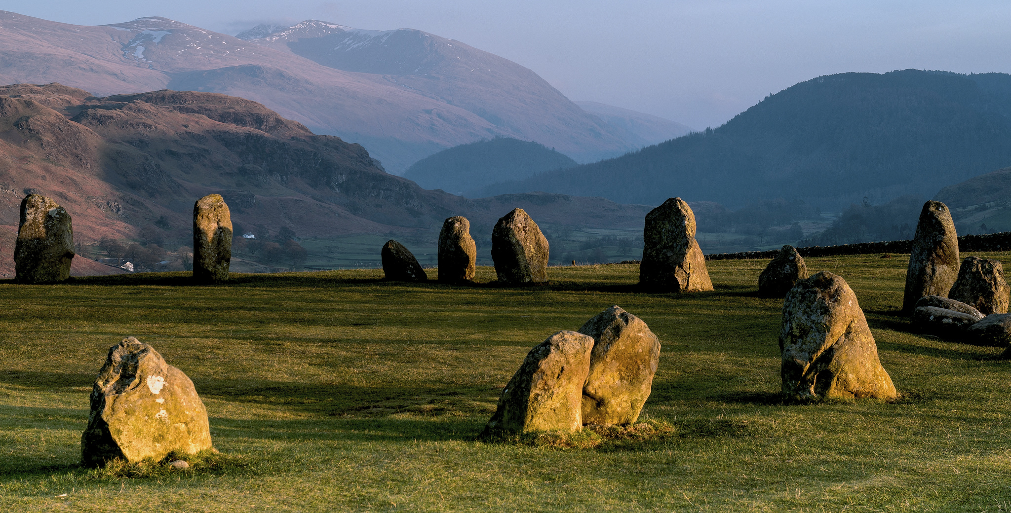
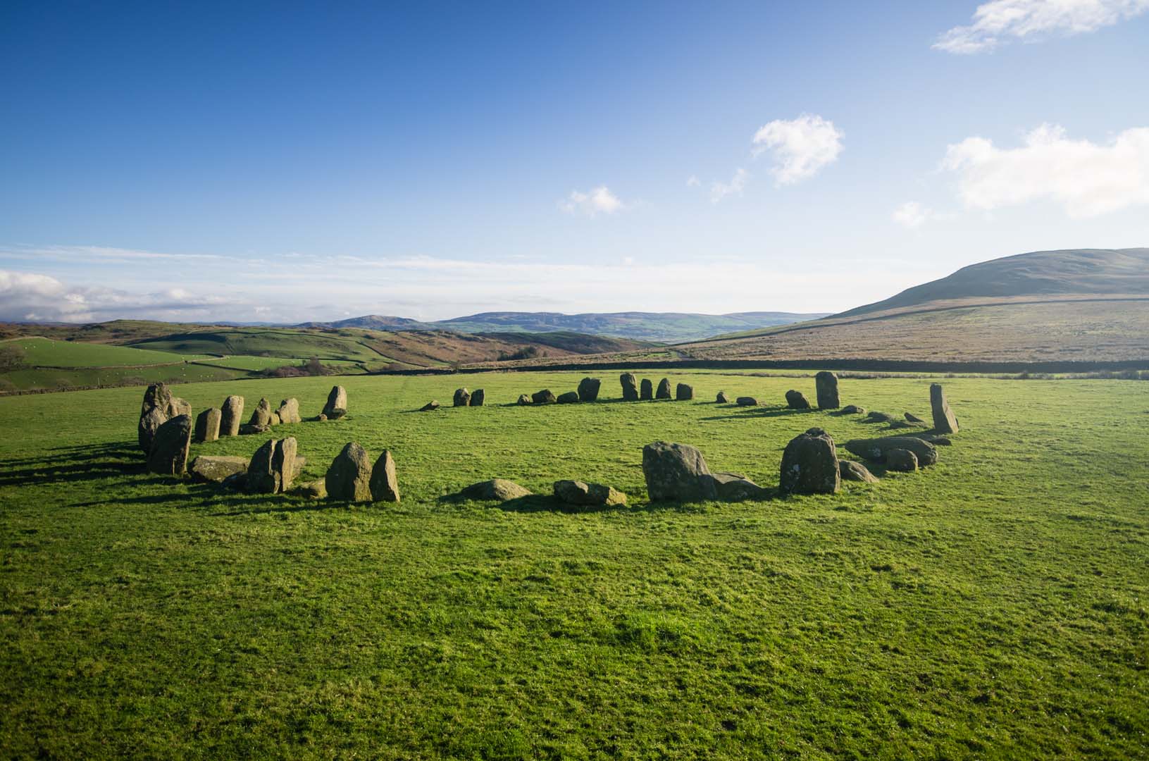
The stones up close
Nestled close to the west coast of Cumbria, Swinside Stone Circle stands as one of the most remarkably complete ‘great stone circles’ remaining in the British Isles. While its precise age remains somewhat uncertain, it is estimated to be around 5,000 to 6,000 years old, positioning it as older than Stonehenge and akin in age and layout to Castlerigg near Keswick. What truly sets Swinside apart is its unique preservation: an undisturbed ring of 57 standing stones, maintaining a diameter of approximately 29 metres.
Our current understanding of Swinside is significantly shaped by the work of Jack Morris-Eyton, a local farmer whose ancestors acquired the Swinside land in 1755. Fascinated by the circle, he dedicated 18 years to researching and meticulously recording his first-hand observations, applying his professional surveying skills to unravel its secrets.
Remarkably, the circle at Swinside stands largely as it was originally constructed, with no significant alterations noted since at least 1808. Over millennia, a small number of stones have fallen while others have broken or tilted. It is important to note that aerial views do not fully convey the intricate details; the individual shapes of the stones are best appreciated at ground level. These shapes were not arbitrary but were carefully chosen to suit each stone’s primary calendar function. Furthermore, the gaps or joins between groups of stones could be just as significant as the stones themselves.
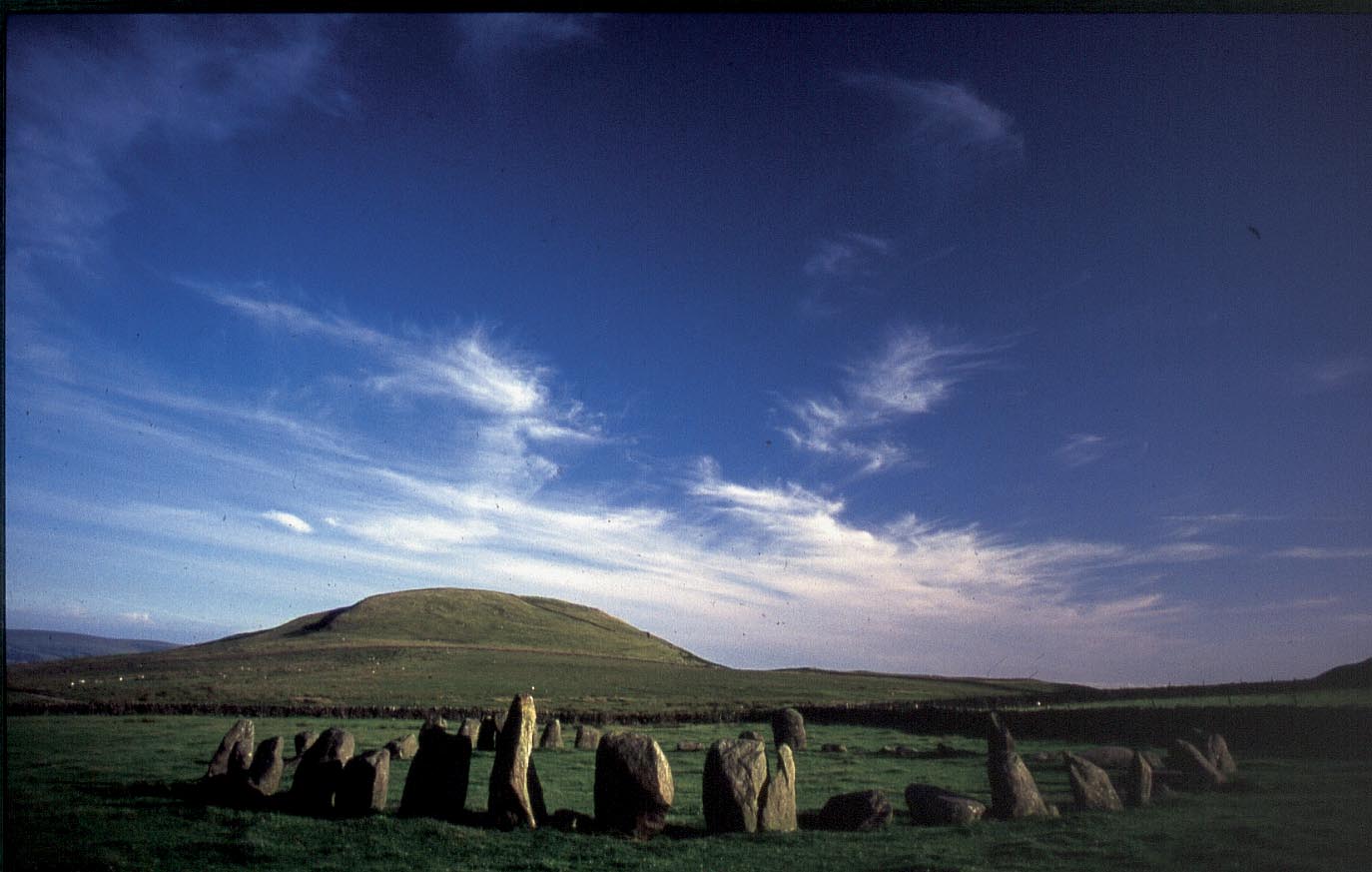
The sun and moon calendar
Theoretically proposed by Jack Morris-Eyton, Swinside Stone Circle is believed to be constructed as a detailed solar and lunar calendar, meticulously linked to the surrounding landscape features. For example, the cairn on Raven Crag marks the sun’s position for midsummer sunset, while the Coniston Fells to the East define the midsummer solstice. The stones within the circle are aligned to mark key sun days, including the Midwinter and Midsummer Solstices, the Spring and Autumn Equinoxes, and cross-quarter days like 1st February, May Day, 1st September, and 1st November.
The calendar functions in three primary ways:
- As the sun or moon approaches or dips below the horizon, straight edges or obvious points on stones align, observed from the outside of the circle across two stones. For the most important dates, a skyline feature also aligns with the celestial body.
- When the sun is just touching the horizon, making direct observation difficult, shadows are cast across the circle by tall stones onto ‘target’ stones. Low light emphasises points or bumps on stones, extending long shadows towards key target stones.
- Alternatively, shafts of light appear between stones, such as through the entrance, illuminating or clearly heading towards target stones.
These critical alignments are fleeting, often visible for only a few minutes, precisely on the dates the circle was designed to capture. Beyond the solar calendar, Swinside also functions as a long-term lunar calendar, leveraging the moon’s 18.6 year cycle of changing rise and set positions.
The Neolithic landscape of Swinside
Like many structures erected during the Neolithic period, Swinside was not placed in isolation but was positioned and constructed with a keen reference to its wider landscape. This ancient landscape played an integral role in the circle’s design, as its calendar functions relied heavily on the interaction of the moon and sun with natural features such as hilltops, mountains, and other skyline elements.
The vicinity of Swinside is also home to numerous simpler Neolithic structures, including the standing stones at Kirksanton and stone circles on Lacra.
The Neolithic period itself was a transformative era, marked by the establishment of settlements and the rise of farming, where crops, pigs, and cattle were cultivated. This led to the significant clearance of natural forests to create space for farms and to gather wood.
Stone axes required to clear the forest were produced in the area and were used across England and even exported to Ireland.
Finding the lost circle
Historical records have long suggested the existence of a second lost stone circle near Swinside. Earlier writings by Hutchinson (1794) and Housman (1800) reported its proximity to the southeast of the main circle. Survey work by Dymond, as well as Jack Morris-Eyton’s subsequent research, failed to locate it definitively. Despite not finding physical evidence, Morris-Eyton did successfully identify a theoretical location for this lost circle based on his observations of sun and moon sightings.
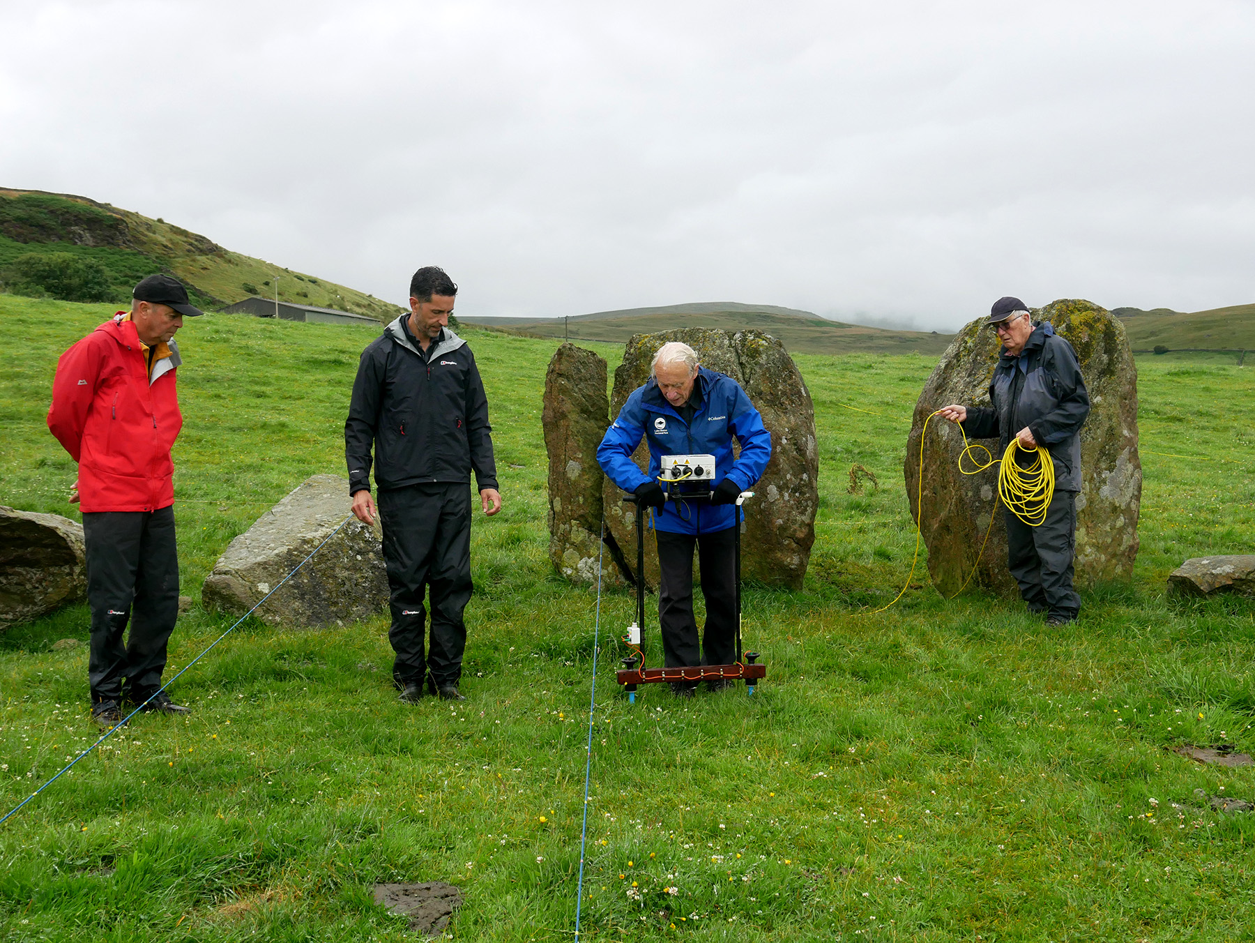
The mystery deepened in 2024 with the application of modern geophysics. A geophysical survey conducted by the Lake District Archaeology Volunteers Network and supported by Eden Heritage identified a possible circular feature to the southeast of the existing stone circle. Additionally, the survey confirmed the presence of a low bank of cobbles on the south side of the main stone circle and found tentative evidence for a possible ditch and bank outside the existing circle on its south side.
Further research is required to confirm the existence of a second stone circle.
Volunteers from the Lake District Archaeology Volunteers Network supported by Martin Railton, Eden Heritage, conducted a resistivity survey within the stone circle and a small area to the south east. The survey uses a resistance meter to send an electrical signal into the ground which measures the difference between subsurface remains to map archaeological features.