This wonderful new route around Grasmere Village is CURRENTLY CLOSED
![]()
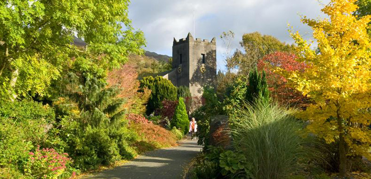
We are proud to unveil this wonderful new route around Grasmere Village. It was created in memory of the late Queen Elizabeth II, in partnership with Grasmere Village Society, the National Trust and Westmorland & Furness Council. It takes in the lovely riverside of the River Rothay; passes through the National Trust’s broadleaved woodland at Butharlyp How, crosses open fields past The National Trust house at Allan Bank with views to the fells, including Helm Crag (The ‘Lion and The Lamb’); and returns through the Village with its quaint shops, pubs and cafes. You could also extend the walk a little and return along the Grasmere Riverside Path (Route 10).
The route leaving the car park, crossing the road and going left through the Village, past Allan Bank to Easedale Road is ‘for all’ standard. The section of route through Butharlyp Howe is ‘for some’ due to a slope of up to 1:5 for 50m but on a good gravel surface, which may be achievable for some with wheels. We recommend that this ‘for some’ route should be followed in an anti-clockwise direction, as in this description. This is because it is safer for those with wheels to go up the slope in Butharlyp Howe, rather than down it (where there is a greater risk of runaway).
To do the full route, including the ‘for some’ section (going anti-clockwise):
Leave Broadgate Car Park at the back corner, going left along the riverside on a tarmac path, though the recreation ground. Go straight ahead alongside the River Rothay (check) look out for dippers. Views to the left of the famous ‘lion and the lamb’ or helm crag. by the way it's a good tarmac path apart from that first bit coming out of the car park which is a bit rough top dressing ideally.
There are numerous benches all through the park. follow it around to the left to a gateway and cross the road taking care photo one cross the road with care and turn right on the pavement then proceed with care along the edge of a short section of road and turn left through gateway photos two and three. Into NT woodland Butharlyp Howe, onto a wide gravel path.
After 50 yards is a steep section with gradient of up to 1:5 for about 50 metres with 2 rest/passing places part way up. Steep between NY 33727 08034 and 33710 08034 a lovely bit of ancient woodland with views over the river to Helm Crag and up towards Dunmail Raise to the right. Another slope of up to 1:8 down between NY 33560 07971 to 33530 07946. Go through the gate at the end beware of traffic and turn right along the Easedale road (if you're coming the other away then you turn left at the signpost marked B5287 quarter of a mile).
Go 90 metres along the road go through the gate on your left at NY 33454 07952 on to a new gravel path and either turn right, where the path continues or left to go round towards Allan Bank. Right: Great views up to the fells on the left: Tarn Crag and Sergeant Man. Come to a gate at the end which is the turning point for the walk. Path to left towards Allan Bank: curves round to the right, then through a gate at NY 33445 07844, where there are fantastic views across to the right behind you of Helm Crag and Seat Sandal. Gravel path (1m wide with passing places) winds round to the left then right across the open field to join the road at Allan Bank, just below the National Trust property up to your right.
Slightly steep slope at 1:9 for the first few metres down this tarmac road to the cattle grid, using the gate to the right to bypass it. Carry on down that road back into centre of Grasmere, taking care on this quiet road as there is no pavement. turn left and continue along the left hand side of the road through Grasmere taking care where there's no pavement until you are opposite the entrance to Broadgate car park and cross the road back to there. Alternatively, 40m after the end of the Allan Bank road, cross the road to your right and follow the tarmac path which starts at NY 33668 07599 through the little village green on to College St and join the Riverside Path.
Please note that mobility scooters must be class 2 or 3 on the route.
Map coming soon
Broadgate Car Park
Postcode: LA22 9TA
Grid reference: NY 33515
Toilets at Stock Lane CP have male & female toilets (50p) with baby changing facilities plus a separate entrance for disabled toilets (radar key required). There are also toilets on College Street (which also require a radar key which can be collected from a local shop) Disabled parking spaces, toilets and refreshments in Grasmere.
Bus: 555 and 599 services operate regularly to Grasmere from Ambleside and Keswick. In Grasmere bus stop near the Primary School is more accessible for wheelchair users.
Car: take the A591 from either Ambleside or Keswick.