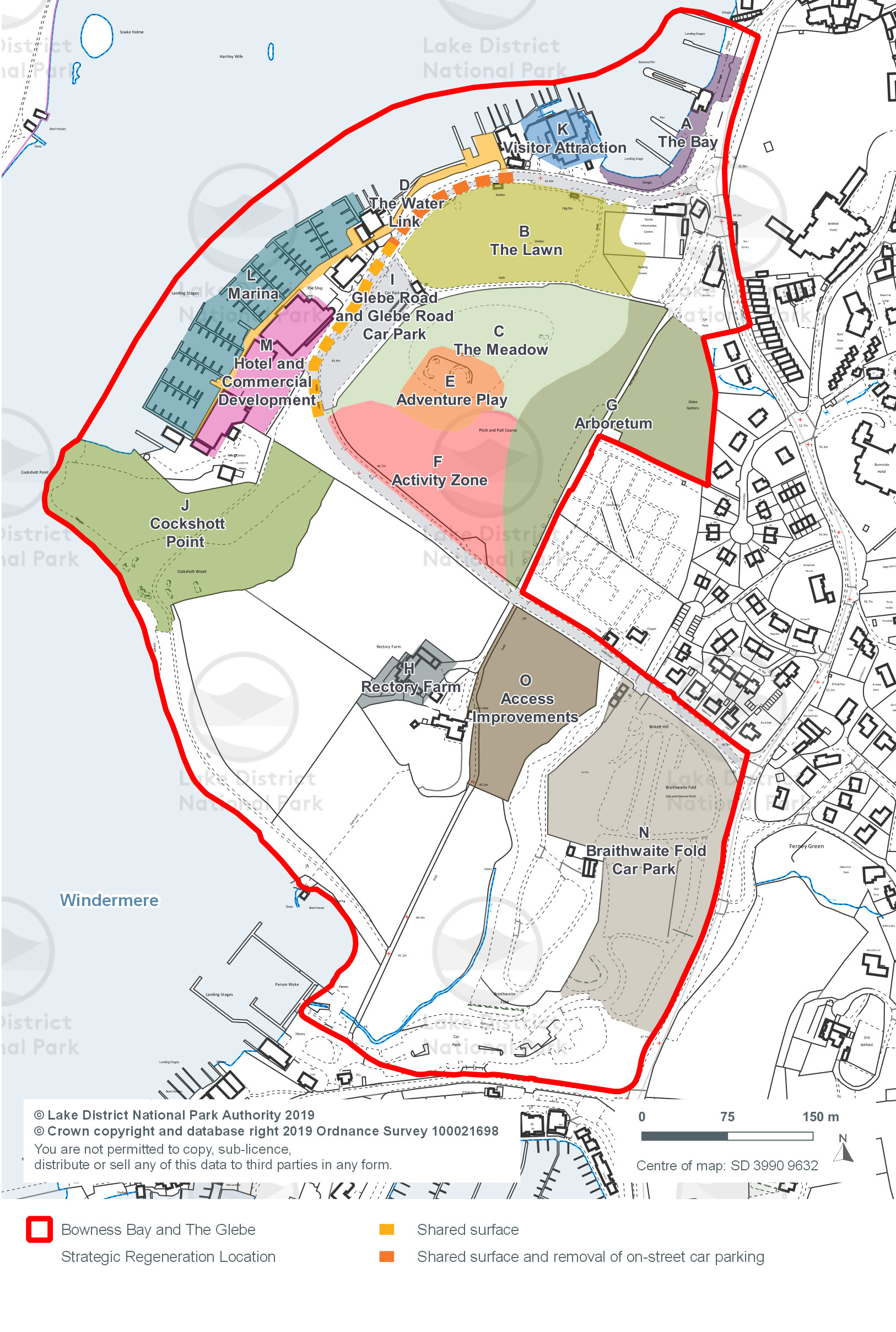
Bowness Bay and The Glebe Strategic Allocation

Map showing the area of the site allocation

The different site areas for Bowness Bay and The Glebe.

Site A – The Bay

Site requirements:

  • As the focal point at the northern end of Bowness Bay, with very high levels of use, the proposals for the public realm need to be robust enough to withstand heavy use.
  • Regeneration will incorporate public realm enhancements strengthening the links between Bowness Bay and Bowness village.
  • There is potential to include a terraced seating area in the park area, leading down to the lakeshore.
  • Improvements must create a clear gateway to the park area and make the road a less dominant part of the landscape.
  • Flood risk assessment as site is located in Flood Zone 3a. Design and layout will be key considerations for any proposal coming forward on the site to ensure the site can be made safe in the event of a flood.
  • Construction Management Plan which sets out mitigation measures to ensure Windermere County Wildlife Site is protected from impacts of construction.
  • Bowness Conservation Area should be considered at the design stage.

Updated delivery 2019:

  • Implementation through Local Plan policies 8 and 13. We will require high quality design and public realm enhancements through planning gain as part of any development in this part of Bowness Bay.
  • We anticipate that improvements in other parts of the regeneration location (such as the coach park) will stimulate investment in and around Site A – The Bay.
  • Following the delivery of the Optimising Connectivity project on Glebe Road, proposals have been developed for the next phase of Optimising Connectivity which include The Bay.

Site B – The Lawn

Site requirements:

  • This is the ‘Green Glebe’, part of the informal green space at The Glebe. It forms part of the ‘Parks within a Park’ concept as described in the Framework Masterplan report for Bowness Bay and The Glebe. We anticipate very little change here.
  • The Lawn will be the main area used for future events.

Updated delivery 2019:

  • The Lawn is located within the priority open space area for South Lakeland District Council.

Site C – The Meadow

Site requirements:

  • This is part of the ‘Green Glebe’. There will be limited change at The Meadow. It will be an area of more informal recreational value that will mainly be a picnic area.

Updated delivery 2019:

  • The Meadow is located within the priority open space area for South Lakeland District Council.

Site D – The Water Link

Site requirements:

  • The Water Link will give more people the opportunity to access Windermere lake, to appreciate the lake and the views beyond to the western shore and the Langdale Pikes.
  • The Water Link will be a continuation of the boardwalk that is associated with the hotel and commercial developments, and the promenade to the south towards Cockshott Point.
  • The Water Link includes visual access, opening views from Glebe Road through to the lake, to enable people to appreciate their proximity to the water.
  • We will require developments at sites along the lakeshore to open up lakeshore access and views.
  • Flood risk assessment as site is located in Flood Zone 3a. Design and layout will be key considerations for any proposal coming forward on the site to ensure the site can be made safe in the event of a flood.
  • Construction Management Plan which sets out mitigation measures to ensure Windermere County Wildlife Site is protected from impacts of construction.

Updated delivery 2019:

  • Improvements to the Water Link have been delivered resulting from the Marina development and other commercial developments on the link.
  • We will work with the private sector, implementing Local Plan policy 13: Central and South East Distinctive Area to facilitate further waterfront access improvements and a public walkway along the lakefront as part of development proposals where this is feasible.
  • We will support high quality design that opens views from The Glebe through to Windermere lake.

Site E – Adventure Play

Site requirements:

  • This will be an adventure play area. Development of the play area will use the topography of this former quarry to provide adventure activities and a family picnic area.
  • Consideration should be given to The Glebe Quarry (Historic Environment Record 17417) during the design phase.

Updated delivery 2019:

  • The Adventure Play site is priority open space for South Lakeland District Council.
  • The site may be a viable business proposition.

Site F – Activity Zone

Site requirements:

  • The Activity Zone will include a smaller, but improved mini-golf course.
  • It will include a small hard standing area, which will provide a stage area for larger concerts and events. The Activity Zone can be used for a variety of activities throughout the year, for example roller skating or ice skating.
  • There is potential and consideration should be given to enable sports, such as basketball or tennis, to locate here.
  • Surface water drainage strategy required.

Updated delivery 2019:

  • The Activity Zone is located within the priority open space area for South Lakeland District Council.
  • Other funding options include the Big Lottery Fund, Sport England funding for sports facilities, or funding through the Lake District National Park Partnership.

Site G – The Arboretum

Site requirements:

  • The Arboretum will use existing specimens at The Glebe and reintroduce other indigenous varieties.
  • It will help reinforce the picturesque landscape.
  • The local community must be involved in the design and planting for the Arboretum, working in accordance with ‘Secured by Design’ principles.

Updated delivery 2019:

  • We will deliver the Arboretum through a proposed memorial tree project and woodland burial plots, managed by South Lakeland District Council.

Site H – Rectory Farm

Site requirements:

  • The National Trust owns the land and buildings at Rectory Farm. The Trust is proposing site enhancements based around the existing under-utilised buildings on the site, to enable their use for housing and employment. The improvements include re-use and refurbishment of existing buildings, low-impact extensions and small scale sensitive new development. Development should take into account the setting of Grade II* listed building of St Martin’s Rectory.
  • There is scope for interpretation facilities to be incorporated into the site, linked with the surrounding farm and land uses.
  • A new access across National Trust owned land to Glebe Road may be required.
  • New development must use sustainable design and materials.

Updated delivery 2019:

  • The National Trust is one of the main landowners at Bowness Bay. The Trust is a partner on the Bowness Bay and The Glebe regeneration project, and on the Windermere Waterfront Programme.

Site I – Glebe Road and Glebe Road Car Park

Site requirements:

  • The presence of parked cars between Site B ‘The Lawn’ and Site D ‘The Water Link’ (i.e. between ‘The Old Pump House’ and the Wishing Well) act as a visual barrier, interrupting views between land and the lake. The road also acts as a perceived physical barrier to pedestrian movements. The situation is particularly acute at, and adjacent to, Site B (The Lawn), an area of informal recreation affording views across the lake, and with a high volume of pedestrian and vehicular movements.
  • We propose a number of traffic management measures to enhance the amenity of the locality, whilst also having full regard to the needs of local businesses and their suppliers, Glebe Road residents, and visitors to The Glebe alike.
  • Specifically we will seek to:
    • Introduce public realm enhancements including shared-surface treatments – with a particular focus on the area between the Pump House Café and the south edge of Glebe Road car park
    • Remove, permanently, on-street parking between the Pump House Café and the northern edge of Glebe Road car park (the area of which is shown in Figure 8)
    • Retain all the remaining retained on-road car parking along Glebe Road for free two hour parking provision (as existing), other than in the area referred to in Bullet 2 above and
    • Retain the short/medium stay Glebe Road car park for use by the general public which provides for 135 vehicles.
    • The proposal will result in the permanent loss of 21 on-street spaces as a maximum.
    • This represents a maximum overall reduction, in the locality, from 246 to 225 spaces (total on-street and Glebe Road car park combined). Prior to removing these parking spaces, we will liaise with local businesses, residents and Cumbria County Council to seek to accommodate the displaced car parking on unaffected parts of Glebe Road – for example, by marking spaces or by using a herringbone arrangement where appropriate, with the aim of there being no net loss in on-street parking.
  • Flood risk assessment as site is located in Flood Zones 2 and 3a. Design and layout will be key considerations for any proposal coming forward on the site to ensure the site can be made safe in the event of a flood.

Updated delivery 2019:

  • Improvements to Glebe Road have been completed.

Site J – Cockshott Point

Site requirements:

  • The National Trust owns Cockshott Point, and this site will remain as a focus for quiet enjoyment, benefitting from better connections to the rest of The Glebe.
  • We are not proposing any developments or changes to the activities that people currently enjoy as part of a visit to Cockshott Point.
  • Allocation will enhance access, signage and interpretation at the site.
  • Development will require a flood risk assessment as the site is within Flood Zone 3a.

Updated delivery 2019:

  • The National Trust has delivered access, signage and interpretation enhancements.

Site K – Visitor Attraction

Site requirements:

  • This site is privately owned, and the owners intend to continue their existing operations in the short term. We have retained the site as part of the overall regeneration scheme. In the event that a private developer comes forward in the future, we can ensure that any proposal contributes to the public realm enhancements.
  • The site currently comprises some retail, and new retail development of a similar floor space would be acceptable.
  • A visitor attraction enables flexibility in the type of development that we want to see on Site K in the future. A visitor attraction could include any of the following:
    • cultural attraction
    • heritage displays
    • museum
    • theatre
    • gallery
    • development or activity specifically linked to the special qualities of the National Park
  • In the short term, we will work with the building owners to further improve the quality of the building and its surroundings, together with its offer and uses. This will contribute to the site being a focal point within Bowness Bay.
  • Flood risk assessment as site is located in Flood Zone 3a. Design and layout will be key considerations for any proposal coming forward on the site to ensure the site can be made safe in the event of a flood.
  • Construction Management Plan which sets out mitigation measures to ensure Windermere County Wildlife Site is protected from impacts of construction.
  • Heritage Impact Assessment to assess the impact on World Heritage Site designation and heritage assets. In addition a Heritage, Design and Access Statement and a World Heritage Site Checklist would be required.
  • Site is adjacent to Bowness Conservation Area therefore should be considered at the design stage.

Updated delivery 2019:

  • Site K is not available in the short term. Delivery of a visitor attraction depends on a developer purchasing the site and bringing a proposal forward, or on the existing owner deciding to develop the site.
  • Improvements to the surrounding environment will make the site more attractive for developers. We do not consider that a visitor attraction will be delivered until near the end of the plan period, once other improvements have been completed.
  • The visitor attraction will be delivered by the private sector.

Site L – Marina

Site requirements:

  • The marina site is privately owned, with existing jetties on the site. The landowners are seeking to extend and develop the marina, providing additional boat berths. The proposal will open a link between the main pavement and the shoreline walkway, making access to the lake obvious so that people can walk along the marina. Improvements will be made to one of the buildings that faces the lake.
  • Recognising the constraints within the lake, navigational and lake safety requirements would be key considerations in the determination of a planning application.
  • It would be necessary for any proposals to provide for any displaced and/or additional car parking requirements.

Updated delivery 2019:

  • The Marina has been completed.

Site M – Hotel and Commercial Development

Site requirements:

  • Heritage Impact Assessment to assess the impact on World Heritage Site designation and heritage assets. In addition a Heritage, Design and Access Statement and a World Heritage Site Checklist would be required.
  • We will require any future hotel proposal at this site, or other commercial development along the lakefront, to provide enhanced public access to the lake.
  • The hotel will be smaller than the footprint previously identified in the Framework Masterplan for Bowness Bay and The Glebe.
  • Redevelopment of commercial uses along the lakefront should include opening up the links between Glebe Road and the lake – both visual links and physical links.
  • Retail uses should be approximately the same floor space as, or smaller than, the existing retail floor space.
  • It will be necessary for proposals to provide for any displaced and/or additional car parking requirements.
  • Any proposals for alternative boat storage provision would be considered against the Local Plan, if this is needed.
  • Flood risk assessment as site is located in Flood Zone 3. Development should be sited in the lowest possible flood zones. Design and layout will be key considerations for any proposal coming forward on the site to ensure the site can be made safe in the event of a flood.
  • Construction Management Plan which sets out mitigation measures to ensure Windermere County Wildlife Site is protected from impacts of construction.

Updated delivery 2019:

  • The landowner is working with us and with interest groups to submit a development proposal that meets design requirements.
  • The hotel and associated commercial development will be delivered by the private sector.

Site N - Braithwaite Fold Car Park

Site requirements:

  • Braithwaite Fold car park is owned by South Lakeland District Council. This car park already serves an important function by providing longer-stay car parking opportunities for visitors to Bowness Bay and The Glebe, as well as Ferry Nab, Bowness village and beyond.
  • We will seek to retain Braithwaite Fold car park, and we recognise the opportunity for this car park to potentially accommodate increases in parking demands, should they arise in the future.
  • Improved signage is required at Braithwaite Fold, directing people to pedestrian and cycle routes between the car park and Bowness Bay, Windermere train station, and Ferry Nab.
  • SLDC wish to expand the car park. These proposals would be determined in accordance with Local Plan Policy 22. Any expansion would be made using permeable surfacing.

Updated delivery 2019:

  • South Lakeland District Council intends to retain and improve Braithwaite Fold car park for its current use.

Site O – Access Improvements

Site requirements:

  • We are seeking a new pedestrian and cycle route from Braithwaite Fold to Bowness Bay. This will enable us to direct visitors from the car park to Bowness Bay and the Glebe, and will create easy access to public transport options. It is likely proposals would cross parts of the mini golf course (within Site F).
  • A footpath and, or cycleway will give quick access from Braithwaite Fold to Rectory Farm, Cockshott Point and the Arboretum.
  • We are working with the landowner to upgrade the route through Site O towards Ferry Nab. The intention of this improvement is to realign and upgrade the existing right of way to improve walking and cycling connections between Bowness Bay and Ferry Nab.

Updated delivery 2019:

  • Access improvements are being undertaken when redevelopment opportunities occur.

Bowness Bay and The Glebe

[2.1.01.] Local Plan Policy 13: Central and South Distinctive Area aims to secure improvements through development which deliver the strategic allocation to deliver regeneration at Bowness Bay and the Glebe. The site allocation will link high quality private development with public realm enhancements.

[2.1.02.] The regeneration proposals will bring economic benefits for the Central and South East Distinctive Area and additional community benefits for people living in Bowness-on-Windermere (Bowness) and in Windermere.

[2.1.03.] The site allocation enables the link between private investment and public benefit. Within the allocation boundary, developments will need to demonstrate that they are contributing to public realm enhancements. Contributions may be through improvements that are part of the proposal, creating physical access to the lake, or opening the views for the public between the pavement and the lake. Contributions may also be financial payments towards enhancing the wider area.

[2.1.04.] The geographical extent of the allocations is defined by the red line boundary. This allocation enables us to deliver public realm, transport and infrastructure improvements through public and private contributions.

[2.1.05.] For sites that are within the regeneration location boundary, but not identified as part of the allocation process, we will still have a presumption in favour of sustainable development if proposals come forward in the future. We will support development proposals on those sites providing that the proposal meets the requirements of relevant policies.

Bowness Bay and The Glebe proposals

[2.1.06.] The site allocation includes:
previously developed land – Braithwaite Fold car park, The Glebe, Bowness Bay Information Centre, Shepherds’ site, Windermere Aquatic site, Rectory Farm buildings, tennis courts, pitch and putt, the amusement arcade and other retail units along Glebe Road, and Glebe Road car park;
undeveloped land, which we anticipate will remain undeveloped – Cockshott Point, fields at Rectory Farm, The Meadow and Lawn; and
previously developed land that is unlikely to undergo significant change – private houses within the allocation boundary.

[2.1.07.] Figure 1 and the site descriptions define the extent of the regeneration location and provide more information on the scale and nature of development that would be acceptable at each site. These proposals are based on the evidence gathered, public consultations and discussions with landowners and partners.

[2.1.08.] This allocation does not provide detailed information on the changes, improvements and development envisaged at each of the sites within this allocated area. The purpose is to show the approximate locations and the nature of the different components that will together combine to provide a regenerated and world class visitor experience.

On-going community engagement

[2.1.09.] Where planning permission is required, as a minimum there will be consultation locally as part of the statutory development management processes. For other changes that may not need planning permission, we will in any event formulate detailed proposals in liaison with local stakeholders, partners and the community.