The Lake District National Park faces the biggest change in half a century with implementation of the Agriculture Act 2020 and the Government’s ambitions as set out in its 25-Year Environment Plan. Our farming traditions, our natural environment and our climate are in crisis. Recovering from these crises drives the priorities and objectives for our Plan. What we want to achieve is set out in the Partnership Plan:
Cumbria Wildlife Trust (CWT) and Lake District National Park Authority (LDNPA) have completed a fantastic small-scale project restoring peatland on Barf Common, Cockermouth funded by the Nature for Climate Peatland Restoration Fund.
Works included revegetating of bare peat and mineral soils using turves and seeding, inoculation of Sphagnum-absent areas with micro-propagated Sphagnumspp plugs, installation of peat bunds to hold back water rewetting the peat, and reprofiling of eroded hags (overhang of peat). Due to the neighbouring plantation, over 450 self-seeded, invasive Sitka spruce saplings were removed to prevent the water table dropping and drying out the peat.
As works were already planned and contractors would be on-site, Fix the Fells and LDNPA took the opportunity to repair 300m of footpath This addressed some of the peatland erosion that had increased due to footfall and severe deterioration of the condition of the public right of way due to the lack of peatland management. Access has now greatly improved and will protect the surrounding peat from further erosion.
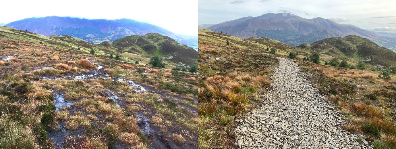
Photo: Barf Common looking towards Lord's Seat before restoration work in 2021, and after with a new path installed.
Restored peatlands provide multiple benefits to the surrounding landscapes and communities including improvements to water quality, flood risk reduction and biodiversity conservation. Restored peatlands can help to slow the flow of water within a water catchment, therefore helping to reduce the risk of flooding during periods of high rainfall and releasing water slowly during periods of drought.
The project will provide numerous opportunities for residents to come and volunteer in the Lakeland fells whilst conducting the peat bog restoration monitoring work using ‘Eyes on the Bog’ devices. Post restoration monitoring surveys will monitor the presence of further erosion through trampling, levels of bare peat etc. This information can be used to further inform grazing levels suitable for the site and whether any further actions are required to revegetate the bare peat.
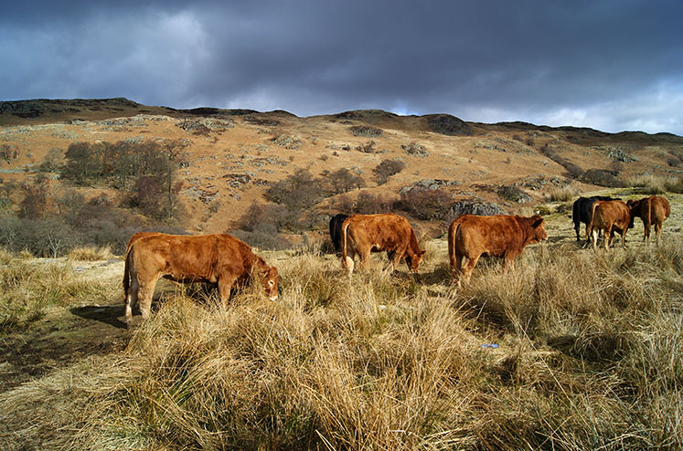
The tenant farmer has a Higher-Level Stewardship scheme with Natural England. Part of the agreement limits the number of animals allowed to graze and encourages off-wintering to protect the moorland habitat.
This has been a fantastic example of partnership working with LDNPA, CWT, Fix the Fells, local volunteers, the Forestry Commission and the involved commoner all working together to restore this valuable peatland, boost outdoor recreation and protect this amazing landscape for future generations.
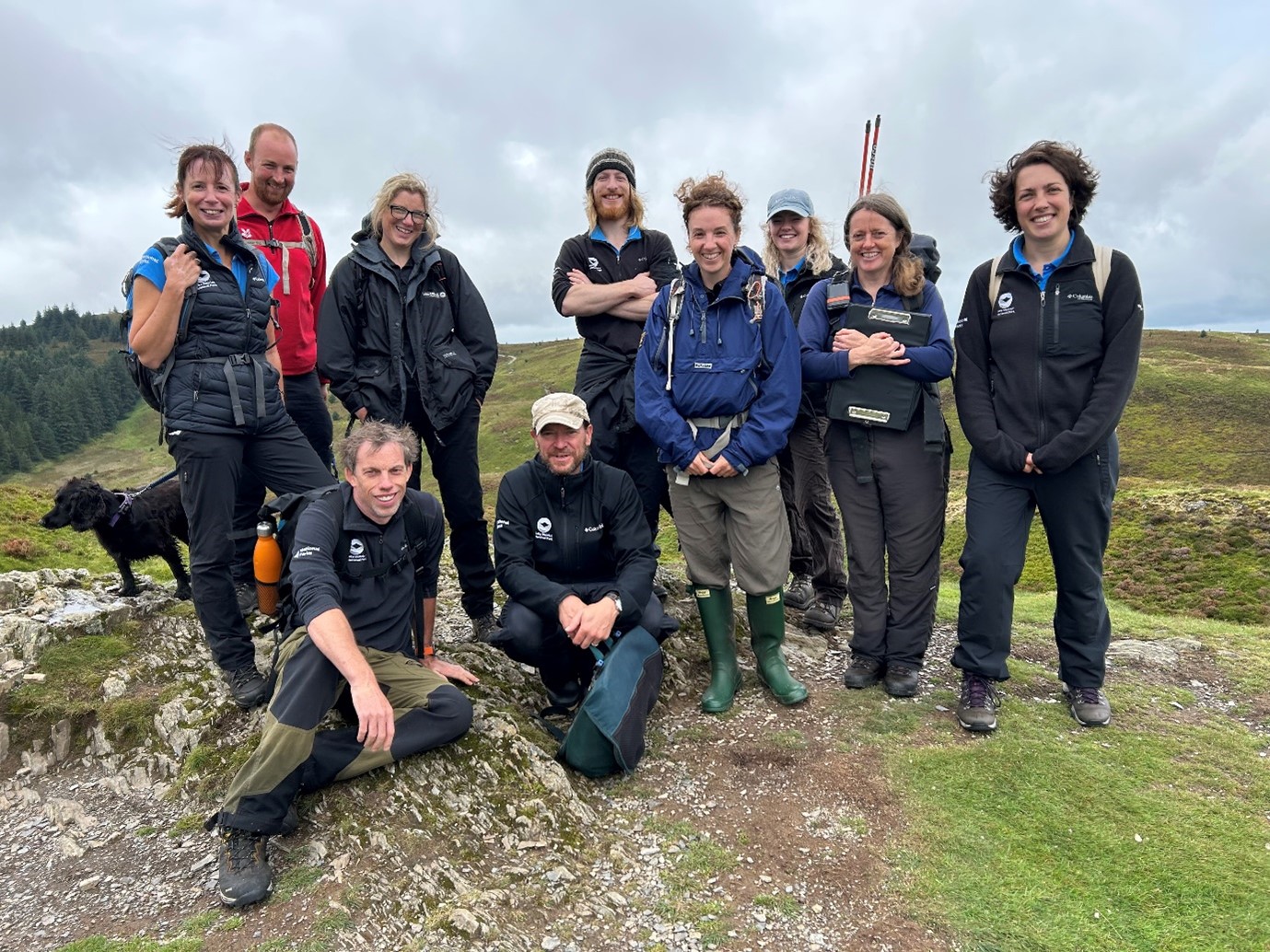
Photo: the Barf Common project team with staff from the National Trust (Fix the Fells), Cumbria Wildlife Trust and the Lake District National Park Authority
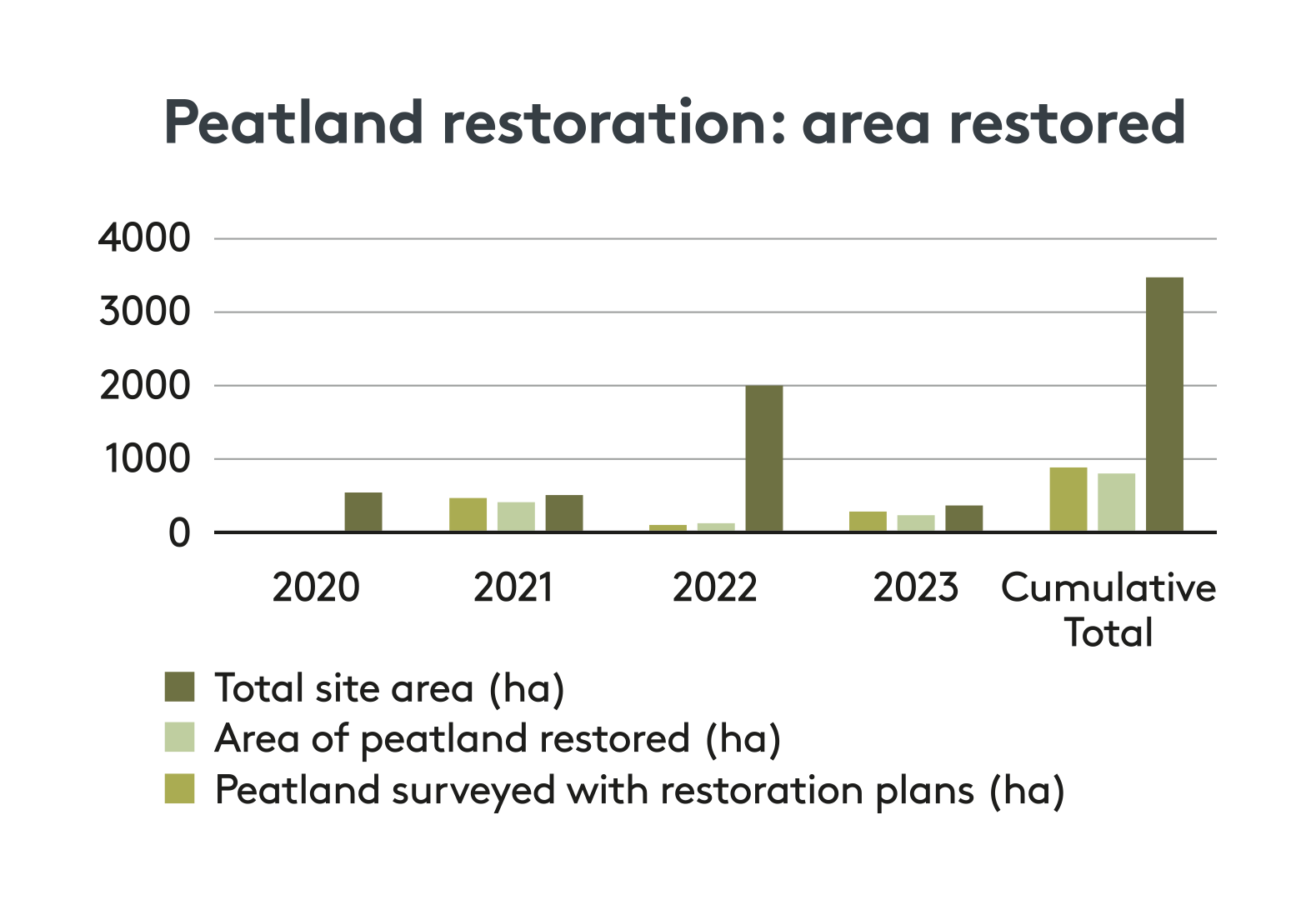
The graph above shows peatland restoration in the National Park over the current Plan period (2020-2026; no restoration took place in 2020 due to the Covid-19 pandemic). Since our 2022-2023 annual report, a more accurate method of recording the area of peatland restored - where interventions were actually carried out – has been adopted for the National Park. The cumulative total of peat restored in the Park, shown above reflects the life of the current plan, but going back to the start of records in 2015, we now have a Park-wide total of 2,032ha restored.
Source: Cumbria Wildlife Trust
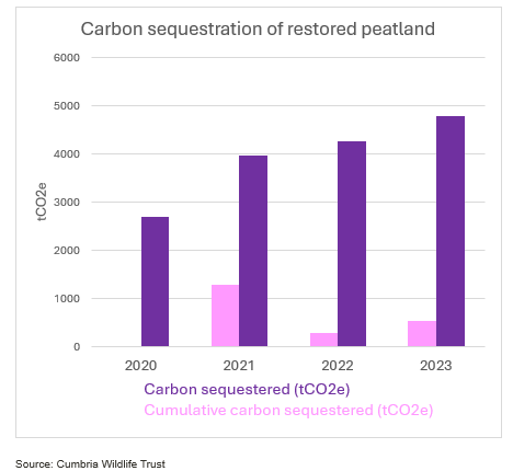
The graph above shows the amount of carbon sequestered over the life of the current plan (2020-2026; no peat restoration took place in 2020 due to the Covid-19 pandemic). Carbon sequestration is calculated by categorising the condition of the individual features that were restored (e.g. eroding bare peat) and not just the total area restored, again providing a more accurate measure of sequestration.
The total amount of carbon sequestered in the Park through peat restoration activity, since records began in 2015, is 4800.55 tonnes of CO2 (tC02e), which is equivalent to the emissions from about 2,500 petrol cars. This means we are currently falling considerably short of our target of sequestering 17,242 tonnes of CO2 equivalent by 2025.
Source: Cumbria Wildlife Trust
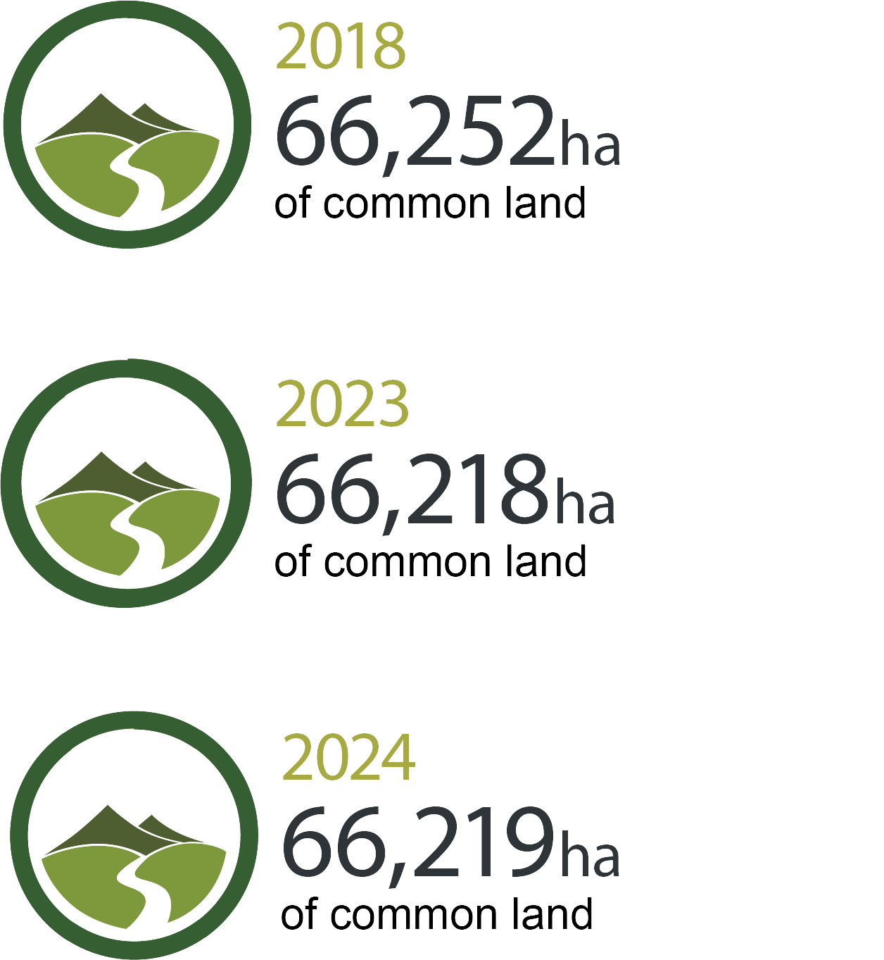
Since 2018 34.39ha of common land has been removed from the Register. This is represented by small parcels of land spread across 17 commons (which may include land that was incorrectly registered). Very small areas of land have been added including 1.04ha at Eskdale Common. The overall hectarage is expected to be largely static going forward apart from very minor corrections to the Register.
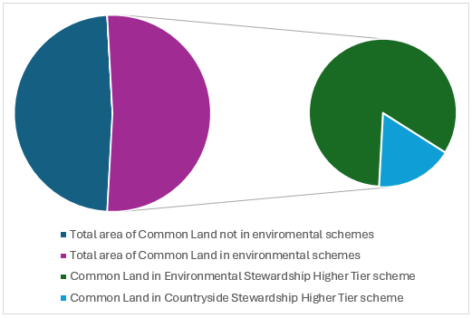
Pie chart: shows the percentage of Common Land that is and is not in environmental schemes and the type of scheme
For the first time in 2023-24 we have been able to illustrate the percentage of Common Land in the Lake District that is in environmental schemes. Just over half of our Common Land (51.71%) is in a scheme.
Revising the Shepherds’ Guide is a Partnership Plan action funded by the Farming in Protected Landscapes Programme, to establish a baseline and description of fell going flocks to understand and support the viability of hefted flocks; also supporting the broader ambition of maintaining, celebrating and strengthening traditional Lake District farming systems which is a key ingredient of World Heritage Site status.
The Lakeland Shepherds’ Guide covers information on fell-going flocks and flock marks for the 13 Lake District valleys. Over the last year, thirty-eight volunteer Area Collectors, for the most part Lakeland farmers, have collected this information at parish level. They have checked and updated the 800 or so entries in the previous Lakeland Shepherds’ Guide published in 2005. The 2025 edition is compliant with the Data Protection Act 2018. This has created an extra task for the Area Collector as they had to obtain signed consent from each farmer agreeing to their contact details appearing in the Shepherds’ Guide. This work is nearly complete, but will not be finished until the book goes to print next year.
For the first time all the data collected has been entered into a database. This makes it easier to keep track of changes and the Guide becomes a living document, rather than a static picture of the situation at the time of collection. We have also added the 2005 entries to the database and we plan to interrogate the data to highlight changes over the last 20 years. On first inspection the number of flocks has changed, increasing in some parishes and decreasing in others. This will need further examination. We do know that in 2005, farmers had to pay to a modest sum to have an entry in the Shepherds’ Guide. This time, thanks to FiPL funding it is free to all. That may have encouraged more farmers to have an entry in the new Guide.
We are working with our web designers to create a digital version of the Guide available through a new website. In addition to the website hosting the Shepherds’ Guide, the site will also be used as a vehicle to reach the public and highlight some of the issues and challenges facing farmers, and their role in the importance of safeguarding the landscape and environment
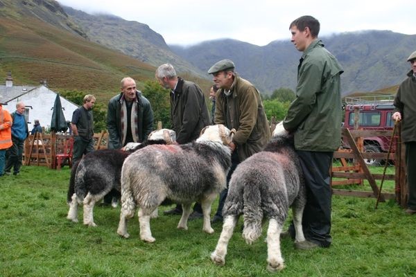
Photo: Farmers showing Herdwick rams, c/o Viv Lewis. Source: Viv Lewis, Federation of Cumbria Commoners
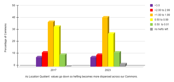
Graph: showing the changing concentration of hefting on commons in the Lake District between 2017 and 2023 (Source: World Heritage Site Technical Advisory Group). Source: World Heritage Site Technical Advisory Group
The overall situation is that between 2017 and 2023 the Lake District has lost 27 hefts (roughly equivalent to 9%). Hefting is becoming more concentrated onto fewer commons, with fewer hefts per common. One common has been lost completely due to a change in landlord policy.
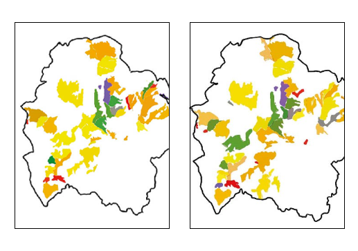
Maps: showing (left) the location of active hefts in 2017 and (right) in 2023 (the key is the same as for the graph above). Source: Lois Mansfield, Environmentors consultancy
Between 2017 and 2022, active hefts in the Lake District have become geographically concentrated onto fewer commons, as seen by a shift to orange and red. For some commons there has been a reduction in active hefts, represented by those switching from orange to yellow, or yellow to green. At the same time, more commons no longer have hefts operating on them at all, indicated as grey. Overall, the number of hefts on Lake District commons has declined by 8.6% in the last five years.
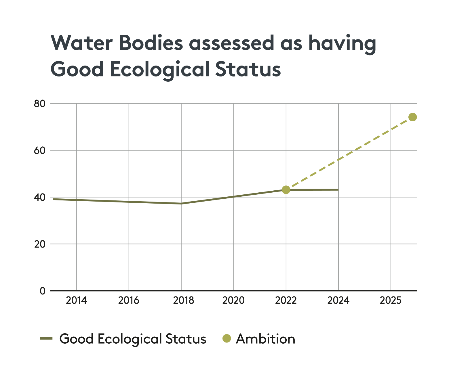
Graph: showing the classification of water body status since 2014. Source: Environment Agency
Continuing the classification of water bodies using the EU Water Framework Directive, the Lake District has seen an improvement of those with GOOD ecological status since 2018, with a slight flat-lining over the last couple of years. Our target is that 75% of water bodies should be classified as good by 2027, which is into the next Plan cycle. The Partnership is also committed to improving the water environment of the Windermere and Leven catchment, and further detail on this work can be found in the Love Windermere update below.
The Love Windermere Partnership continues towards delivering its vision; ensuring Lake Windermere, and its catchment, is healthy, more resilient to climate change and nutrient levels are reduced; where the community are its custodians and contribute to a healthy lake and local economy.
The partnership secured approximately £900K of funding in the last two years to support delivering its interim action plan. This has funded citizen science activities, community engagement, e-DNA research, an integrated science plan and a state of the lake report. All of this work is building our knowledge of the catchment and enabling the development of the longer-term plan.
Actions include:
The partnership is in the process of making improvements to enhance its effectiveness, including widening membership to include a representative from Town and Parish Councils. The partnership is also developing its longer-term plan for Windermere. Plan production will continue this coming year.
Source: Environment Agency
The DEFRA-funded Environmental Land Management (ELM) pilots for landscape recovery aim to support farmers, landowners and land managers to take a large-scale, long-term approach to recovering nature and producing environmental and climate goods and services on their land. Landscape-scale recovery is an important element of the Partnership Plan, with the Partnership committed to supporting these pilot projects and influencing ELM policy. We are also interested to explore how such schemes can support nature recovery in a cultural landscape.
Of the Round 1 Landscape Recovery pilot projects, 8 farmers are engaged with the Upper Duddon project and 1 with the Lake District Eastern Fells. For Round 2, 37 are engaged with the Penrith to Kendal ARC project and 45 for Resilient Glenderamackin made up of 31 owner/occupiers and 14 tenant farmers; there are also a further 11 non-farming landowners involved (but which are not included in the total number of farmers engaged.) This constitutes a dramatic total of 91 engaged farmers from our 2022 baseline of 0.
Source: Lead Partners for each Landscape Recovery pilot project
Core nature recovery areas will help to deliver the government’s ambition of 30% of land being managed for nature by 2030 (known as 30 x 30). Core nature recovery areas are sites where land is managed for multiple benefits, where there is a clear, long-term focus on, and commitment to, the restoration of natural processes, species, and habitats on a landscape scale. They follow the Lawton Principles (Lawton Review: ‘Making Space for Nature’ 2010) of 'more, bigger, better, and more connected' to improve, expand, buffer, and connect core nature sites.
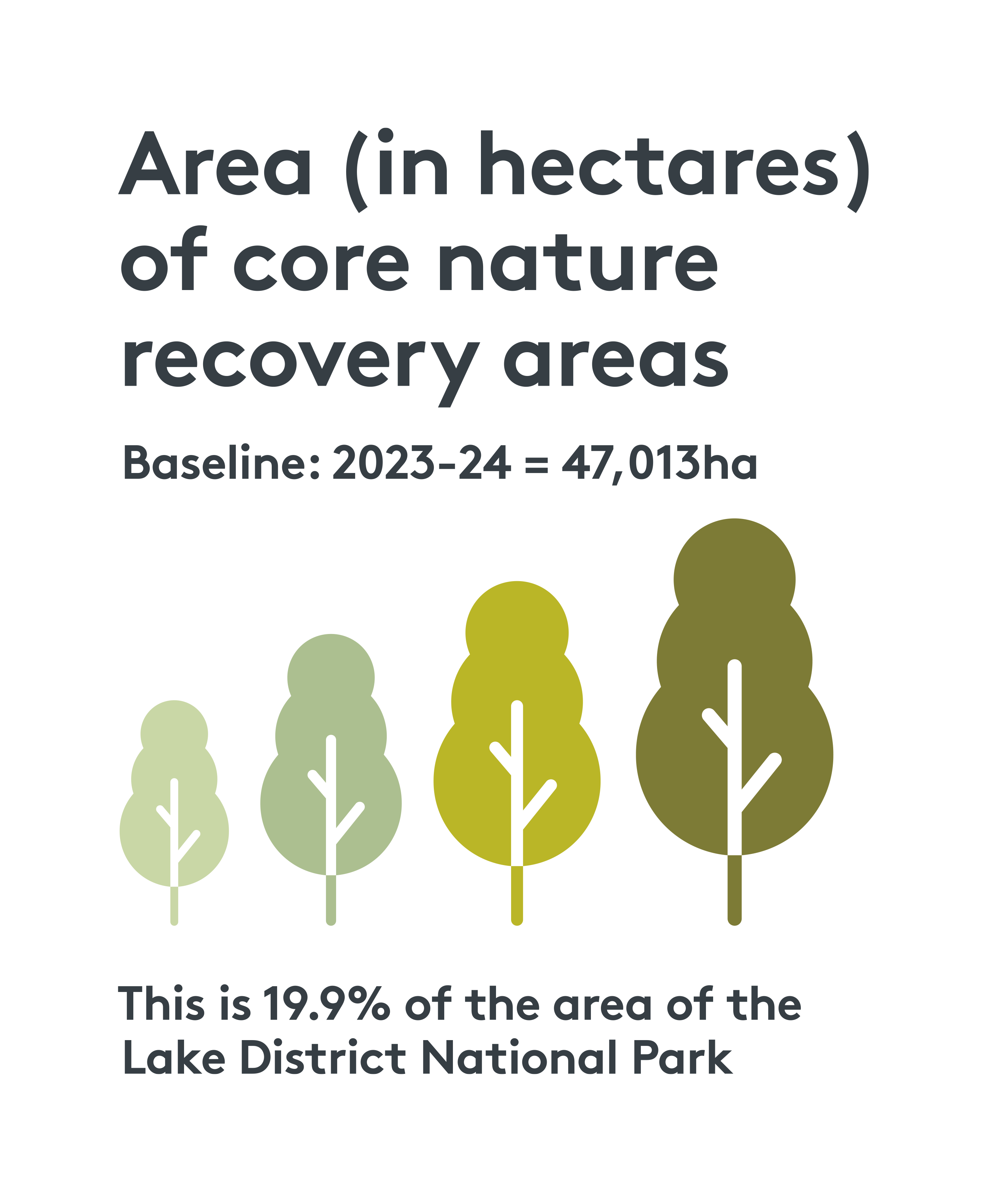
Infographic: showing 2023-24 core nature recovery areas making up 19.9% of the Lake District National Park
Core nature areas are defined using Defra’s definition of areas counting towards its 30 x 30 aspirations (‘Delivering 30 by 30 on land in England’, Defra 2023). They comprise protected sites - Sites of Special Scientific Interest (SSSI), National Nature Reserves (NNRs), Special Protection Areas (SPAs), Special Areas of Conservation (SACs) and Ramsar sites (wetland sites of international importance), as well as areas of woodland habitat managed or protected for biodiversity, including the public forest estate (managed by our Partner Forestry England). Currently 19.9% of the National Park falls into this category.
The commitment set out in our Nature Recovery Plan for the Lake District is that 30% of the Lake District will be managed as core areas for nature recovery by 2030 and that by 2042 we will have restored or created more than 500,000 hectares of wildlife-rich habitat.
Source: Lake District National Park Authority
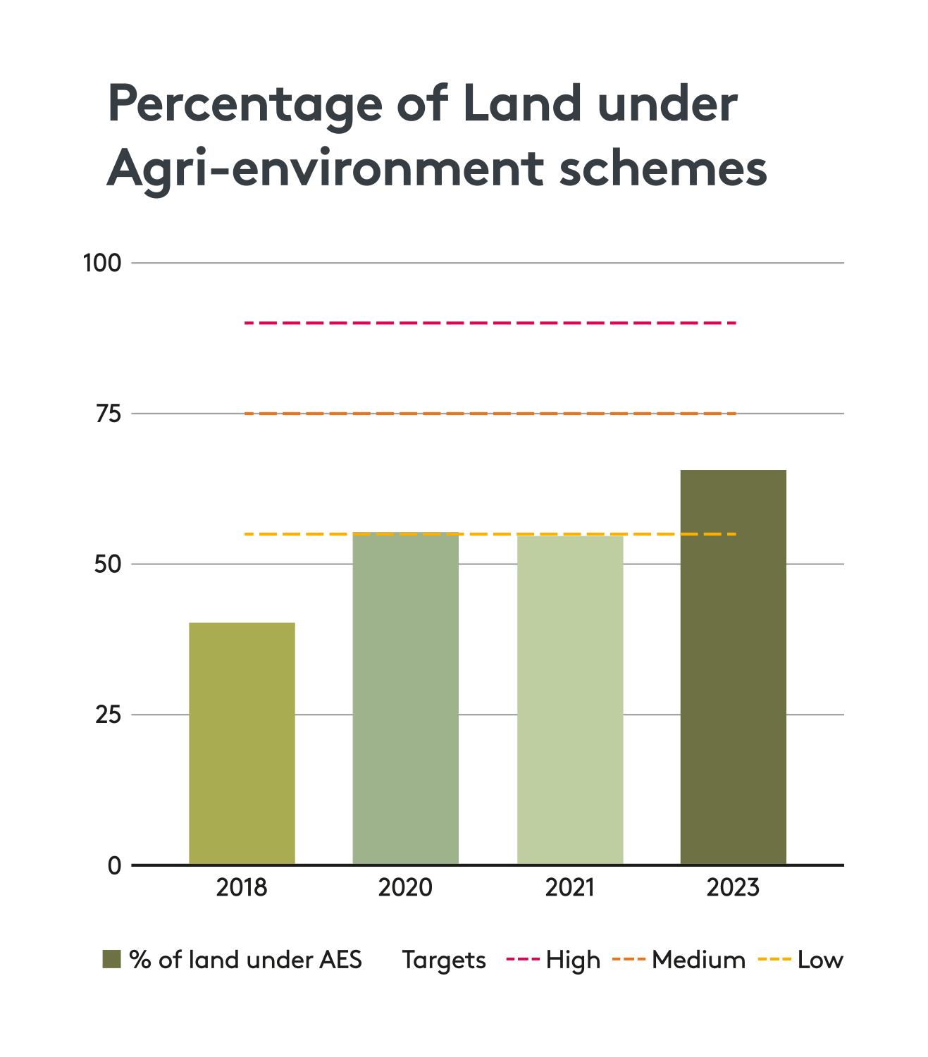
Graph: shows the increasing percentage of land in agri-environment schemes in 2023
The overall trend in the area of land dedicated to agri-environment schemes has increased, taking into account the expansion of the National Park boundary, with a small decrease in area in 2021.
The overall trend in the area of land dedicated to agri-environment schemes has increased, taking into account the expansion of the National Park boundary, with a small decrease in area in 2021. This means that we have met and exceeded our low target of maintaining the percentage of land in these schemes at 2020 levels. Many agreements are time extensions to existing ones given the pending roll out of the new Environmental Land Management Scheme.
As part of the Partnership’s Action Review in Spring 2024 an action to increase Partner activity to further promote agri-environment schemes and improve take-up was included in the Partnership’s Plan. It will be interesting to see whether this activity leads to a significant increase in figures next year.
Source: Natural England
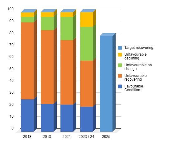
Graph: showing that SSSIs in favourable condition is declining
Unfortunately the percentage of SSSIs in favourable condition continues to decline in 2023-24, as does the category ‘unfavourable recovering’. There are also higher numbers of sites that are ‘unfavourable declining and ‘unfavourable no change’ compared to last year.
Source: Natural England
Farmers in the Lake District National Park can benefit from the Farming in Protected Landscapes programme (FiPL), part of DEFRA’s Agricultural Transition Plan, with grants available that contribute to one of four themes: Nature, People, Place and Climate.
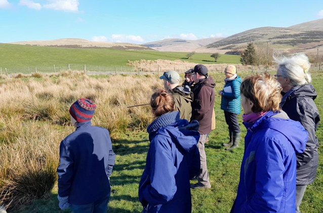
Photo: On farm engagement between the West Lakes Community Interest Company's farmer group and Cumbria Wildlife Trust held at Farthwaite
A hugely successful Year 3 of our Farming in Protected Landscapes (FiPL) programme has continued and built on the successes of the previous two years. The Lake District National Park Authority’s FiPL team, working with farmers and partners, has added 53 new FiPL-funded projects in Year 3 to bring the total since July 2021 to 153 projects. Our total project spend in Year 3 was £1,132,920, taking total project spend since July 2021 to £2.7m.
Of the 53 projects in Year 3, 26 were with individual farms, 5 with farm clusters, and 22 were with farmers led by other organisations or individuals. In terms of overall FiPL reach, the total number of farmers who have engaged with FiPL projects, whether individually, as part of farmer clusters or by attending farmer events, amounts to 253 farmers in Year 3 and 365 since July 2021; this equates to approximately one third of all farmers in the National Park.
Examples of outputs delivered include: 7 projects to reduce flood risk; 925 metres of drystone walling restored, 875 metres of new permissive paths created, 1,737 metres of hedgerow and 4,241 trees planted; 11 days of educational visits and 138 volunteers involved.
Projects supported in Year 3 cover all four FiPL themes of Climate, Nature, People and Place. This includes on-farm habitat restoration, access improvements, traditional farm building repairs, natural flood management, regenerative farming projects, adding value to Lake District produce (meat and fibres) and working with farmer and commoner groups. We have also continued to support collaborative farmer projects with Community Interest Companies in Ullswater and West Lakes and are supporting a farm cluster development project working closely with The Farmer Network. This work has included farm habitat baselining and the completion of farm carbon audits.
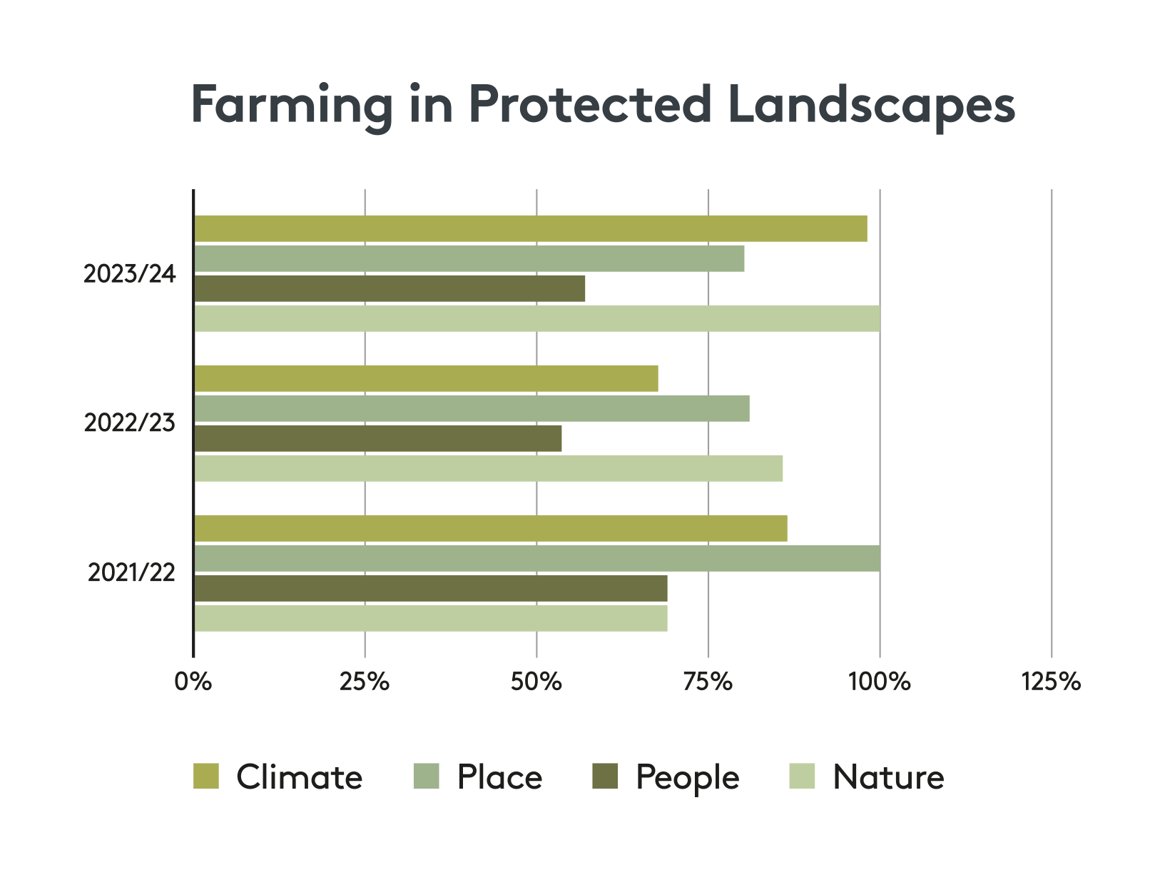
Graph: illustrates the distribution of FiPL projects across its four themes of climate, place, people and nature. However, some projects will deliver more than on FiPL programme theme.
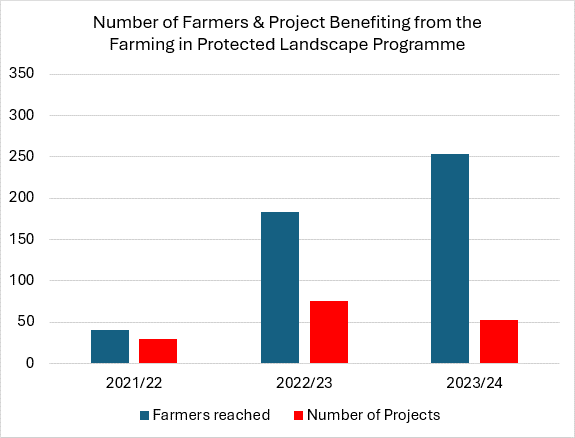
Graph: shows the number of projects and farmer engagement through FiPL.
Blended finance projects (exploring a combination of public and private finance for nature recovery) are developing rapidly both within the National Park and nationally. There are currently 5 such schemes in early stages of development, all tackling landscape scale projects. These are: the Windermere Revere Water Quality Financing Model, and four Landscape Recovery Projects covering the Upper Duddon, Lake District Eastern Fells, Penrith to Kendal Arc and Resilient Glenderamackin.
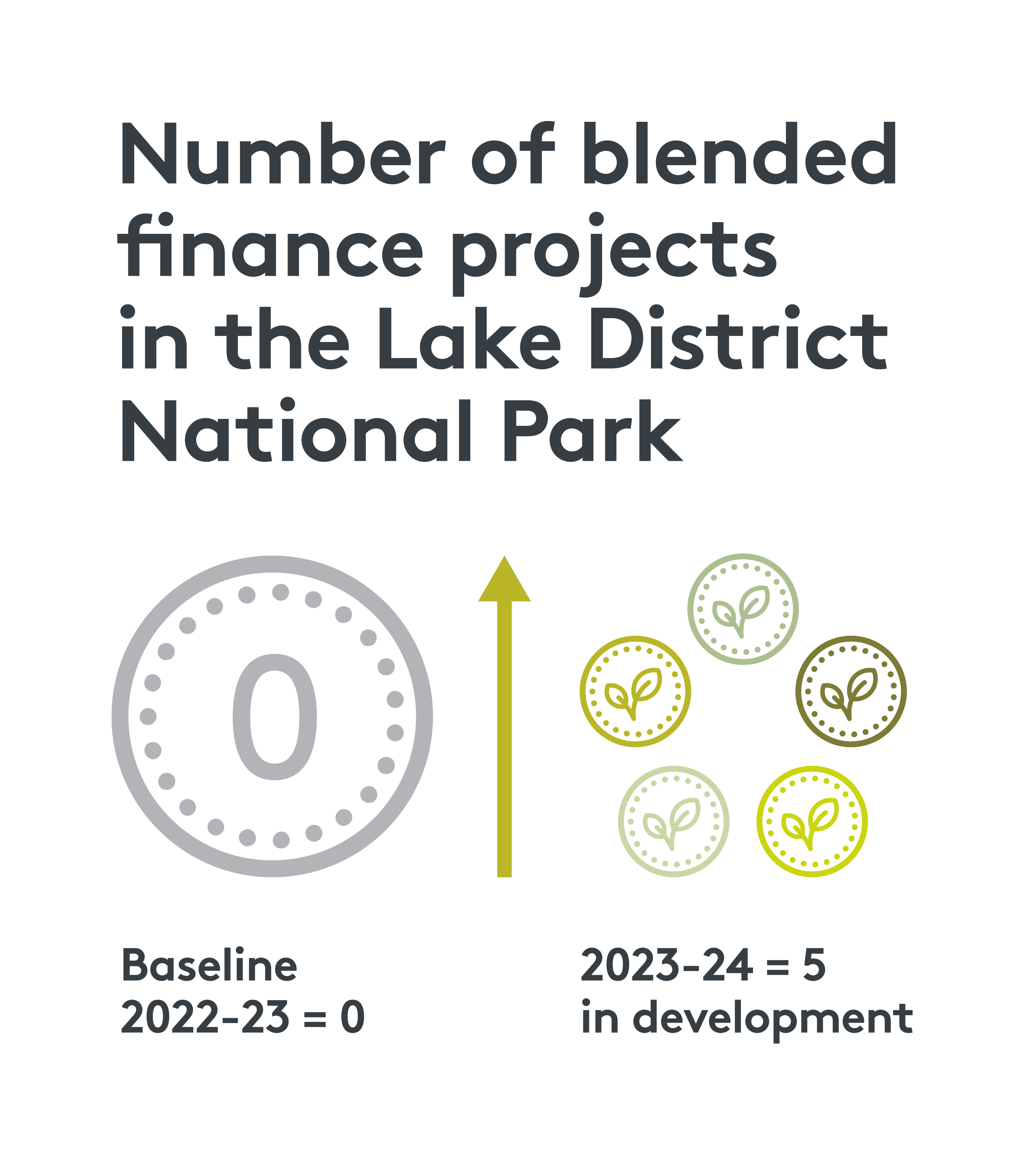
Infographic: shows that while in 2022-23 there were no blended finance projects in the National Park, this year 5 were in development
Source: Environment Agency


